Plan2040 / General Development Plan
Information on the General Development Plan (GDP) can be found on the County's GDP website.
Plan2040 is the General Development Plan for Anne Arundel County. It sets the policy framework to protect the natural environment, shape development of the built environment, provide public services to promote healthy communities, and support a diverse, resilient economy. For more information, check out the Plan2040 website.
Plan2040 was adopted May 3, 2021; approved and enacted May 13, 2021; and became effective June 27, 2021. You can learn more about the legislation regarding Plan2040 on the County Council's website.
The Office of Planning and Zoning produces a Plan2040 Annual Progress Report that provides summary data on implementation of the General Development Plan and highlights achievements from the past calendar year. Learn more about the Annual Progress Report here and sign up for our mailing list to be notified of any other updates related to Plan2040.
The State of Maryland requires that each jurisdiction must review and, if necessary, update its comprehensive plan every ten years. County Code § 18-2-104 requires the Office of Planning and Zoning perform a comprehensive review of the General Development Plan (GDP) every eight years, at a minimum. The most recent GDP, Plan2040, was adopted in May 2021. Sign up for our mailing list to be notified of updates related to Plan2040, and read the section History of Comprehensive Planning and Anne Arundel County, beginning on page 28 in Volume II of Plan2040 for more background.
Green Infrastructure Master Plan
The purpose of the Anne Arundel County Green Infrastructure Master Plan is to provide an identification, decision-making, implementation, and management tool for the County’s natural lands. The overall goal is to create an interconnected network that protects the environment; increases quality of life for residents; provides greater recreation options; improves water quality, aesthetic quality, and biodiversity; and reduces pollution for present and future generations. Conversely, without a managed greenways network, disrupted open and green space will likely increase as development continues, resulting in diminished quality of life for both humans and animals.
The Plan is also used to inform preservation and restoration decisions through collaboration with other County departments as well as third parties that share the same goal. During the County’s development review process, there will continue to be an iterative process where staff works with the applicant to orient development outside of the Green Infrastructure Network or in cases where that is not feasible, position development to have a low impact on the Network.
In 2021, the Office of Planning and Zoning worked in partnership with the Department of Recreation and Park to update the Plan. Find more information by visiting the Green Infrastructure Master Plan website.
The Plan is not a regulatory document; it is designed to identify an interconnected network that helps meet the County’s vision and goals for land preservation, forest conservation, recreation, and pedestrian mobility. It also establishes an implementation plan that identifies possible funding sources, financial tools, or incentives for acquisition, and other elements of green infrastructure–trail construction, education, staffing, remediation, additional planning, maintenance, etc.--as well as opportunities for cross-departmental collaboration. The Plan also identifies future related work outside the scope of this document.
The Green Infrastructure Master Plan was adopted April 4, 2022; approved and enacted April 5, 2022; and became effective April 12, 2022. You can learn more about the legislation regarding the Green Infrastructure Master Plan on the County Council's website.
The Office of Planning and Zoning produces an Annual Progress Report that provides information on progress to conserve and restore green infrastructure in Anne Arundel County. Learn more about the Annual Progress Report here and sign up for our mailing list for notifications related to Green Infrastructure.
Water Sewer Master Plan
The State of Maryland requires each county to develop water supply and sewerage systems in accordance with a county master plan that specifies the extent, adequacy, sizing, staging, and other characteristics of such facilities, so that they are in compliance with State laws relating to water pollution, environmental protection, and land use. The Water Sewer Master Plan must be consistent with the General Development Plan. For more information, see the Water and Sewer Master Plan website.
The Water Sewer Master Plan was adopted March 21, 2022; approved and enacted March 22, 2022; and became effective March 31, 2022. You can learn more about the legislation regarding the Water Sewer Master Plan on the County Council's website.
The Water Sewer Master Plan is updated every three years. To stay up to date, sign up for our mailing list.
Comprehensive Zoning
Zoning is a tool used to guide how land is developed or preserved. The Zoning Map classifies land in the County into zoning districts where different types of land uses–such as residential, commercial, and industrial–are allowed. The Zoning Code includes a set of bulk regulations, such as lot coverage, density, and building height requirements, that help determine the form of development.
The generalized Zoning Map gives a quick view of how the County is zoned. For the zoning of individual properties, you may check the Land Use and Zoning App. For general descriptions of the different zoning districts, please see this Zoning Classifications Guide. For more information about zoning, please refer to County Code § 18-2-106 or see the County's Zoning Administration Website.
Planned land use is a policy map that shows how the County and its residents envision the future use of the land will be, in order to promote a more desirable outcome. The County updated its Planned Land Use Map during the process to develop Plan2040, which the County Council adopted in May 2021. To review the Planned Land Use in your community, check the Land Use and Zoning App.
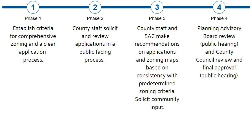
Comprehensive zoning is one procedure for amending the Zoning Map, as per County Code § 18-2-106. Comprehensive zoning occurs after an analysis of the land use, development activity, and trends for either the County as a whole or for a particular section or Region are completed. The comprehensive zoning process provides an opportunity for the County to make changes in zoning, in accordance with the policies and recommendations in the General Development Plan, and ensure that the zoning is made consistent with the adopted Land Use Plan. The County may also use the comprehensive zoning process to rezone property in order to address an identified County or community need.
Maryland State Law requires that zoning be consistent with the General Development Plan, known as Plan2040. County staff conducted an extensive analysis of land use and zoning during the development of Plan2040 and the Region Plans, and identified several zoning consistency issues that should be addressed to help achieve County and community goals.
The Office of Planning and Zoning proposes these consistency changes to align the Zoning Map with the Planned Land Use Map. For example, there are large properties in the County with "industrial" zoning and a planned land use of "mixed use." In these cases, the County may work with the property owners to determine their support for updating the zoning to "mixed use." To take another example, there are also areas of the County with "medium-density residential" planned land use, where existing, well-established neighborhoods are built out at a lower density. In these cases, the County will work with property owners in these neighborhoods to weigh the tradeoffs and benefits of pursuing a lower-density residential zoning district.
When neighborhoods are developed, they are not always built out to the maximum potential density of the zoning district. Changing the zoning to match what was actually built can help the County provide better analysis for infrastructure needs and protect the physical character of an area. Properties that are zoned for more intense development may be subdivided or redeveloped with more and different types of uses than the neighborhood currently has; that can be a desirable change in areas where communities want to see revitalization. In communities that do not want or cannot support more density, higher zoning potential may not be desired.
There are two methods for changing the Zoning Classification assigned to an individual property: Comprehensive Zoning and Administrative Zoning.
Comprehensive Zoning is a process that occurs to make changes in the County’s official Zoning Maps, in accordance with the policies and recommendations in the General Development Plan or other adopted master plans. The Office of Planning and Zoning will propose Comprehensive Zoning Maps that are consistent with the Adopted General Development Plan and the Region Plans. The Comprehensive Zoning Maps will be reviewed and adopted through a legislative process by the County Council for official use.
Administrative Zoning is the method by which an individual may request that a property be reclassified to correct any mistakes made by the County Council during the last comprehensive process or to recognize a change in the character of the neighborhood that would necessitate a change in the zoning. The Administrative Hearing Officer conducts hearings on administrative zoning requests and renders a decision.
There were multiple opportunities for the public to review and comment on proposed comprehensive zoning changes during the region planning process that occurred between 2022 and 2026. In addition to the generalized review windows outlined below, staff held drop-in sessions in each Region and attended community events where the public could review and comment on the draft changes in person. The public could also provide testimony at both the Planning Advisory Board and County Council review stages.
No, the comprehensive zoning process is now closed. You can still pursue rezoning through an individual, piecemeal zoning application. Please click here for more information on individual zoning. Anne Arundel County Code also empowers the Planning and Zoning Officer to correct zoning district lines; this process is called an administrative zoning correction. If you think your property is eligible, please click here.