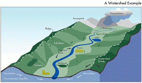
What is a watershed and why is important?
A watershed is a land area that captures rainfall and other precipitation and funnels it to a particular body of water. When it rains in a watershed, the runoff flows downhill to a creek, stream, or river. All of the runoff ends up in nearby waterways without prior treatment in many cases. Since stormwater comes into contact with litter, gasoline, oils, brake pad dust from our cars, pesticides, waste from our pets and many other toxins along its journey, stormwater is a significant source of pollution to our waterways. In fact, all of Anne Arundel County's waterways are considered "impaired" because of excessive levels contaminants, largely a result of untreated stormwater runoff.
Land uses play an important role in how pollution ends up in our waterways. Impervious surfaces such as roads, building footprints, parking lots, driveways and other hard surfaces prevent rainfall from seeping into the ground, resulting in the potential for large volumes of stormwater to run off more rapidly and more directly into our local streams and rivers. Pollutants carried with this runoff reduce water quality and negatively impact stream health. Research shows that as the impervious surface area in a watershed increases, the ecological integrity of surrounding streams deteriorates.
What is my watershed address?
Anne Arundel County consists of 12 primary watersheds and hundreds of sub-watersheds and all of them discharge directly into the Chesapeake Bay. Therefore, the activities that occur in Anne Arundel County have a direct impact on the Chesapeake Bay.
The Bureau of Watershed Protection and Restoration utilizes a watershed based approach to restoring and protecting our waterways. Assessments are conducted on each primary watershed to evaluate land use, water and habitat conditions, establish priorities and goals for improvement and take actions designed to restore and protect our water.
If you know which watershed you live in, click on the name below. Otherwise, if you don't know which watershed you live in you can use the interactive map below to search your address and determine which watershed you live in.
Watershed Description
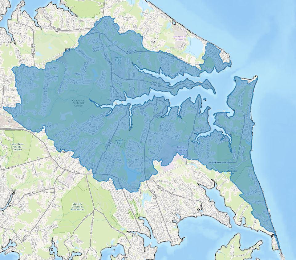
The Bodkin Creek watershed is located in northern Anne Arundel County, near the confluence of the Patapsco River and the Chesapeake Bay. It includes the communities of Poplar Ridge, Bellhaven Beach, Pinehurst on the Bay, Hickory Point, Bayside Beach, Ventnor, Summerfield, Orr Acres, Saybrooke and Windermere Estates.
The watershed drains 5,034 acres of land. It has approximately 18 miles of streams and is divided into 8 sub-watersheds. These 8 sub-watersheds range in size from <1 acre to over 2,995 acres. It is bounded by the Baltimore Harbor watershed to the west and by the Chesapeake Bay to the east. Major tributaries include Back Creek, Main Creek, and Wharf Creek.
The Bodkin Creek watershed land uses are divided as follow: urban 2,730 acres (48%), agriculture 176 acres (3%), woods 2,761 acres (49%), and wetland 16 acres (<1.0%). Impervious surfaces represented by roads, building footprints, parking lots and other hard surfaces cover approximately 13% (~658 acres) of the Bodkin Creek watershed. Some of the major landmarks in the watershed include several County parks including Downs and Poplar Ridge Parks and Compasse Pointe Golf Course.
Watershed Assessment
The Watershed Protection and Restoration Program utilizes a watershed based approach to restoring and protecting our waterways. Assessments are conducted on each of the 12 primary watersheds to evaluate water conditions, establish priorities and goals for improvement, and take actions designed to restore or protect water quality.
A comprehensive watershed assessment for the Bodkin Creek watershed has been completed. The reports include a discussion of the water quality problems and sources of pollution and strategies for improving the water quality in the watershed. Click here to read more.
Local Watershed Organizations
Successful conservation and preservation of Anne Arundel County's watersheds takes teamwork. Here is a list of various organizations that work to protect the Bodkin Creek watershed:
Anne Arundel Patapsco River Alliance
Blue Water Baltimore
Anne Arundel County Watershed Stewards Academy
Watershed Description
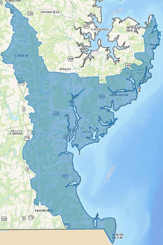
The Herring Bay watershed is located in southeastern Anne Arundel County. It includes the communities of Snug Harbor, Cedarhurst, Sudleys Choice, Traceys Meadows, Franklin Manor, Churchton, Deale, Masons Beach, Owings Beach, Tracys Landing, Highview, Fairview, Fairhaven, Rosehaven, and North Beach Park. The Herring Bay watershed shares political boundaries with Calvert County to the south, and its entire eastern shore is located on the mainstem of the Chesapeake Bay
The watershed encompasses 14,682 acres in drainage and contains approximately 218 miles of streams and is divided into 21 subwatersheds. These 21 subwatersheds range in size from 119 acres to over 2,401 acres. Major tributaries include Broadwater Creek, Rockhold Creek and Tracys Creek.
Impervious surfaces represented by roads, building footprints, parking lots and other hard surfaces cover approximately 6.5% (~824 acres) of the Herring Bay watershed. Major landmarks in the watershed include South County Recreation Center, Southern Recycling Center, Herrington Harbour North and Herrington Harbour South.
A majority of the land cover found within the Herring Bay watershed is classified as mixed woods (41 percent), followed by residential uses with 23 percent, and forested wetlands with 9 percent. Open space, open wetland, pasture/hay, commercial, row crops and transportation individually occupy 2 – 7 percent of the watershed. Industrial activities are less prominent in Herring Bay representing less than 1 percent of the total land use in the watershed.
Watershed Assessment
The Watershed Protection and Restoration Program utilizes a watershed based approach to restoring and protecting our waterways. Assessments are conducted on each of the 12 primary watersheds to evaluate water conditions, establish priorities and goals for improvement, and take actions designed to restore or protect water quality.
A comprehensive watershed assessment for the Herring Bay watershed has been completed. The reports include a discussion of the water quality problems and sources of pollution and strategies for improving the water quality in the watershed. Click here to read more.
Local Watershed Organizations
Successful conservation and preservation of Anne Arundel County's watersheds takes teamwork. Here is a list of various organizations that work to protect the Herring Bay watershed:
Advocates for Herring Bay
Anne Arundel County Watershed Stewards Academy
Watershed Description
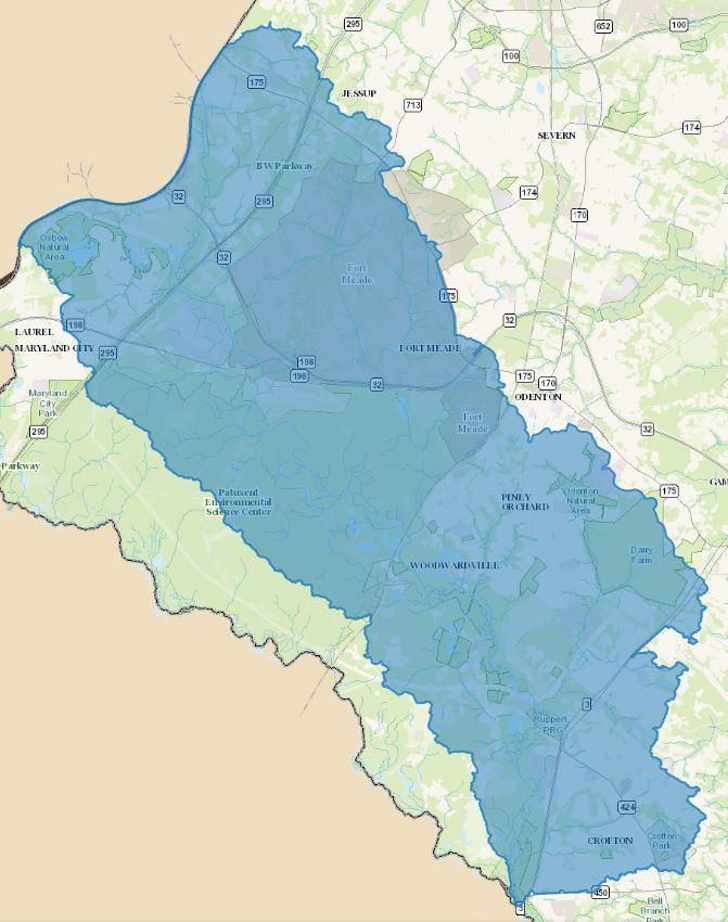
The Little Patuxent watershed is in the northwestern portion of Anne Arundel County. It includes the communities of Annapolis Junction, Russett, Fort Meade, Piney Orchard, Four Seasons, Waugh Chapel, Crofton, Crofton Village, Crofton Mews, Walden, Charing Cross and Saddleridge.
The watershed is part of Maryland’s Patuxent River basin. The Patuxent River basin drains approximately 900 square miles of land, including portions of Anne Arundel, Baltimore, Calvert, Charles, Howard, Prince George’s, Montgomery, and St. Mary’s Counties.
The Anne Arundel County portion of the Little Patuxent watershed encompasses 27,752 acres and contains approximately 181 miles of streams, draining 21 sub-watersheds. The 21 sub-watersheds range in size from approximately 480 acres to 2,675 acres. The Little Patuxent watershed is made up of numerous tributaries draining directly to the Little Patuxent River, as well as three major tributaries: Dorsey Run, which originates in Howard County, Rogue Harbor Branch, and Towsers Branch.
Land use throughout the watershed is diverse, with sub-watersheds to the north (Dorsey Run) dominated by industrial/commercial landuse, sub-watersheds to the west (Patuxent Wildlife Refuge) dominated by forests, and sub-watersheds to the east and south dominated by residential and mixed (commercial/industrial) land uses including the Fort Meade Military Reservation.
In addition, the watershed contains several major transportation corridors including the Baltimore-Washington Parkway (I295) and Maryland Route 32, Route 175 and Route 3 highway corridors, as well as the Maryland Area Rail Commuter (MARC) Penn line and Camden line railway corridors. Impervious surfaces represented by roads, building footprints, parking lots and other hard surfaces cover approximately 16% (~4,347 acres) of the Little Patuxent watershed.
Watershed Assessment
The Watershed Protection and Restoration Program utilizes a watershed based approach to restoring and protecting our waterways. Assessments are conducted on each of the 12 primary watersheds to evaluate water conditions, establish priorities and goals for improvement, and take actions designed to restore or protect water quality.
A comprehensive watershed assessment for the Little Patuxent watershed has been completed. The reports include a discussion of the water quality problems and sources of pollution and strategies for improving the water quality in the watershed. Click here to read more.
Local Watershed Organizations
Successful conservation and preservation of Anne Arundel County's watersheds takes teamwork. Here is a list of various organizations that work to protect the Little Patuxent watershed:
Patuxent Riverkeeper
Scenic Rivers Land Trust
Anne Arundel County Watershed Stewards Academy
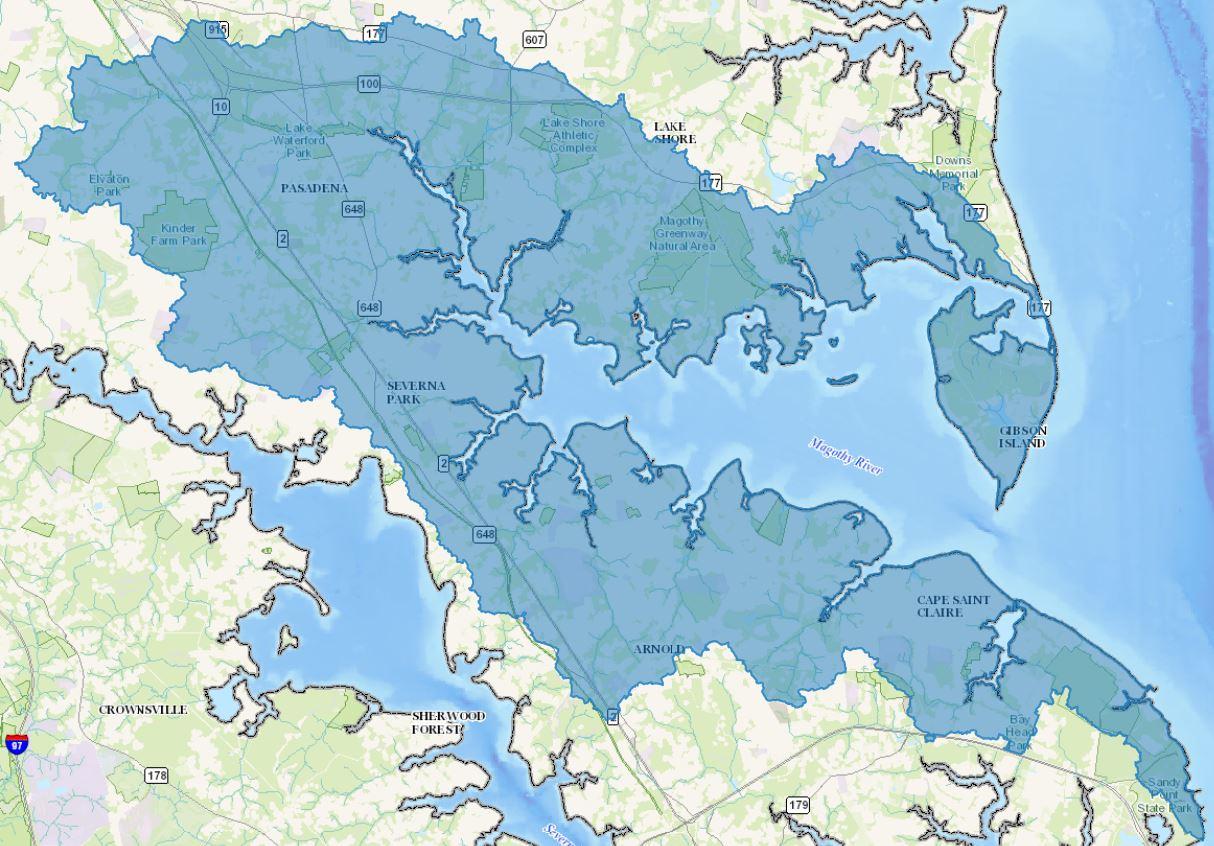
Watershed Description
The Magothy River Watershed is situated in the northeastern portion of the County. It includes the communities of Gibson Island, Long Point, Boulevard Park, Lake Shore, Deerfield, Farmington Village, Earleigh Heights, Cryress Landing, Severna Gardens, Cape Arthur, Manhattan Beach, Old Station Estates, Jones Station, Mago Vista, College Manor, Ulmstead, Bay Hills, Shore Acres, Cape St. Clair, Podickory Point and Revell Downs.
The drainage area of the Magothy River Watershed is approximately 22,802 acres and contains approximately 74 miles of streams draining 68 sub-watersheds. The 68 sub-watersheds range in size from 3 to 1,429 acres. Major tributaries include Magothy Branch, Cockey Creek, Cattail Creek, Cypress Creek, Deep Creek, Dividing Creek and Cornfield Creek.
Many sensitive environmental features including bogs, wetlands, Greenways, and Critical Areas are present within the Magothy River Watershed. Each of these features is important because they provide hydrologic, water quality, and habitat benefits. Wetlands are found throughout the Magothy River Watershed, while bogs are primarily located in the north portion of the watershed.
There is a mix of land use and land cover in the Magothy River Watershed. Residential development collectively represent nearly 54% (~11,000 acres) of the watershed while forests occupy a substantial area of 31.7%. The areas covered by commercial areas, transportation uses, industry, open space, and agricultural activities are all individually less than 5%. Impervious surfaces represented by roads, building footprints, parking lots and other hard surfaces cover approximately 22% (~4,900 acres) of the Magothy River watershed.
The Magothy River watershed includes a portion of the MD Route 2 (Ritchie Highway) corridor from Arnold Road in the south to Jumpers Hole Road in the north. This corridor contains several shopping centers and office buildings including Anne Arundel Community College. In addition, it is home to several County parks including Lake Shore Athletic Complex, Lake Waterford Park, Kinder Farm Park and portions of Broadneck Park and Sandy Point State Park. Other landmarks include Bay Hills Golf Course, Severna Park Community Center and Grey's Creek Bog Natural Area.
Watershed Assessment
The Watershed Protection and Restoration Program utilizes a watershed based approach to restoring and protecting our waterways. Assessments are conducted on each of the 12 primary watersheds to evaluate water conditions, establish priorities and goals for improvement, and take actions designed to restore or protect water quality.
A comprehensive watershed assessment for the Magothy River watershed has been completed. The reports include a discussion of the water quality problems and sources of pollution and strategies for improving the water quality in the watershed. Click here to read more.
Local Watershed Organizations
Successful conservation and preservation of Anne Arundel County's watersheds takes teamwork. Here is a list of organizations that work to protect the Magothy River watershed:
Magothy River Association
Anne Arundel County Watershed Stewards Academy
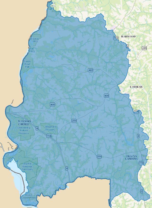
Watershed Description
The Middle Patuxent Watershed is situated in the southwestern portion of Anne Arundel County. It includes the communities of Maryland Manor, Windsor Farm, Harwood Acres, Carrs Grant, Bayard, Lothian Woods, Waysons Corner, Pindell, Lyons Creek, Jewell, Traceys Landing and Greenock. The Middle Patuxent watershed shares political boundaries with Prince George’s County along the Patuxent River to the west, and along Lyons Creek with Calvert County to the south.
The watershed is part of Maryland’s Patuxent River basin. The Patuxent River basin drains approximately 900 square miles of land, including portions of Anne Arundel, Baltimore, Calvert, Charles, Howard, Prince George’s, Montgomery, and St. Mary’s Counties. Anne Arundel County's portion of the Middle Patuxent Watershed has a drainage area of approximately 29,820 acres. Major tributaries include Lyons Creek, Rock Branch, Ferry Branch, Wilson Owens Branch and Cabin Branch. There are 356 miles of streams in the watershed.
Impervious surfaces represented by roads, building footprints, parking lots and other hard surfaces cover approximately 4.8% (~1,172 acres) of the Middle Patuxent watershed. Major landmarks include Jug Bay Wetland Sanctuary, Glendening Nature Preserve and Old South Country Club.
Woods occupy a majority of the Middle Patuxent watershed, representing approximately 38% of the total area. Collectively, residential land cover categories constitute almost 22% of the target territory, and row crops represent the next largest portion of the watershed occupying over 18% of the total area. Commercial, forested wetland, open space, open wetland, pasture/hay and transportation individually occupy 1 – 8 percent of the watershed; while industrial, mining and utilities individually occupy less than 1 percent of the area.
Watershed Assessment
The Watershed Protection and Restoration Program utilizes a watershed based approach to restoring and protecting our waterways. Assessments are conducted on each of the 12 primary watersheds to evaluate water conditions, establish priorities and goals for improvement, and take actions designed to restore or protect water quality.
A comprehensive watershed assessment for the Middle Patuxent watershed has been completed. The reports include a discussion of the water quality problems and sources of pollution and strategies for improving the water quality in the watershed. Click here to read more.
Local Watershed Organizations
Successful conservation and preservation of Anne Arundel County's watersheds takes teamwork. Here is a list of various organizations that work to protect the Middle Patuxent watershed:
Patuxent Riverkeeper
Scenic Rivers Land Trust
Anne Arundel County Watershed Stewards Academy
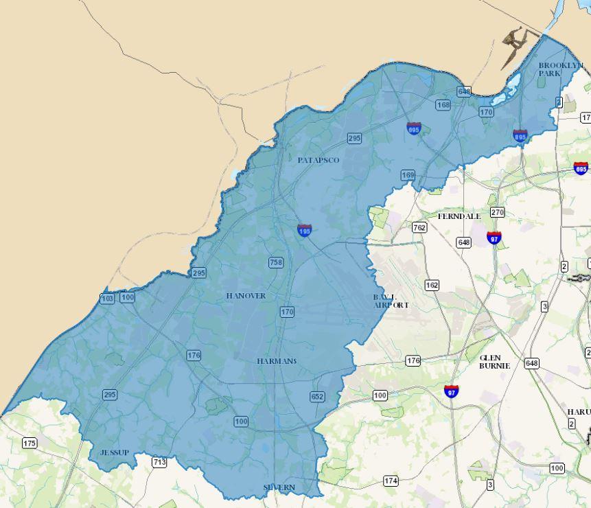
Watershed Description
The Patapsco Non‐Tidal watershed is situated in the northwestern portion of the County. The watershed shares political boundaries with Howard County along Deep Run and Baltimore County along the mainstem of the Patapsco River. The most downstream extent of the watershed bounds Baltimore City in the most northern extent of the County. It includes the communities of Brooklyn Park, Pumphrey, North Linthicum, Linthicum Heights, Linthicum Hills, Kignston Heights, Hanover, Harmans, Severn Hills, Sandal Wood and Stoney Run.
The Patapsco Non‐Tidal watershed is approximately 15,281 acres in area. The watershed includes several named streams including Stoney Run, Piney Run, Deep Run, Holly Creek, and the mainstem of the Patapsco River. These named streams are distributed among 12 sub-watersheds ranging in size from 431 to 2,646 acres. The Patapsco Non‐Tidal Watershed contains approximately 96 total miles of streams.
Land use throughout the watershed varies. Woods occupy a majority of the watershed, representing approximately 37% of the total area. Collectively, residential land cover categories constitute almost 25% of the watershed. Open space represents the next largest portion of the watershed and occupies over 11% of the total area. Industrial, transportation, commercial, and airport land covers all individually occupy 4% ‐ 10% while water, open and forested wetlands, utilities, row crops, residential woods, pastures/hay, and undesignated covers are all individually less than 0.5%. Impervious surfaces represented by roads, building footprints, parking lots and other hard surfaces cover approximately 28% (~4,352 acres) of the Patapsco Non-Tidal watershed.
The Patapsco Non‐Tidal watershed has been developed over the course of several centuries. The earliest documented development occurred in the late 1700’s and has continued to increase, exponentially so, through the present. Development peaked between 1980 and 1999 before stormwater management regulations for water quality were put in place in 1999. However, a significant amount of development has continued to occur even after water quality regulations were developed. The majority of the development in the last decade has occurred along the Baltimore‐Washington Parkway.
The Patapsco NonTidal watershed contains portions of several major transportation corridors including Interstate 695, Interstate 195, MD Route 100 and the Baltimore Washington Parkway. In addition, a majority of the Baltimore Washington Thurgood Marshall International Airport is located within the boundaries of the watershed. Other major landmarks include Patapsco Valley State Park which borders Baltimore County in the north, Arundel Mills Mall, and several County Parks including Pumphrey Park, Overlook Park, Jessup/Dorsey Park and Joe Cannon Stadium.
Watershed Assessment
The Watershed Protection and Restoration Program utilizes a watershed based approach to restoring and protecting our waterways. Assessments are conducted on each of the 12 primary watersheds to evaluate water conditions, establish priorities and goals for improvement, and take actions designed to restore or protect water quality.
A comprehensive watershed assessment for the Patapsco Non-Tidal watershed has been completed. The reports include a discussion of the water quality problems and sources of pollution and strategies for improving the water quality in the watershed. Click here to read more.
Local Watershed Organizations
Successful conservation and preservation of Anne Arundel County's watersheds takes teamwork. Here is a list of organizations that work to protect the Patapsco Non-Tidal watershed:
Anne Arundel Patapsco River Alliance
Anne Arundel County Watershed Stewards Academy
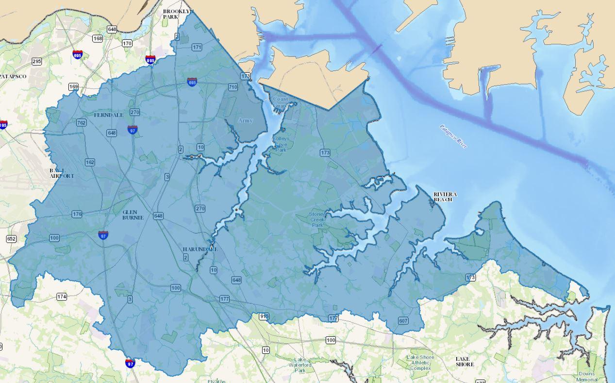
Watershed Description
The Patapsco Tidal watershed is located in northern Anne Arundel County, near the confluence of the Patapsco River and the Chesapeake Bay. It includes the communities of Hillcrest, Brooklyn Heights, Arundel Village, Rolland Terrace, Sunnyfield Estates, Shipley Fairmount, Cromwell Fountain, Ferndale, Furnace Branch, Glen Burnie, Point Pleasant, Glen Burnie Heights, Glen Burnie, Park, Harundale, Marley, Solley, Brandon Shores, Stoney Beach, Riviera Beach, Green Haven, Freetown Village, Old Mill, Fairview Beach, Paradise Beach and Chesterfield.
The Patapsco Tidal watershed drains 30,852 acres and contains approximately 135 miles of streams draining 27 sub-watersheds. These sub-watersheds range in size from 12 acres to 3,367 acres. Major tributaries include Marley Creek, Stony Creek, Rock Creek and Sawmill Creek.
Residential land uses (approximately 40 %) make up the greatest portion of the Patapsco Tidal Watershed. Apart from residential land use, the other large land use/land cover category is woods at 27% of the watershed. Commercial/Industrial uses make of 13% of the land use. Impervious surfaces represented by roads, building footprints, parking lots and other hard surfaces cover approximately 30% (~9,320 acres) of the Patapsco Tidal watershed.
Residential, commercial, and various industrial and transportation uses are well represented in the Patapsco Tidal watershed. Portions of Interstate 695, Interstate 97, Maryland Route 10 and Maryland Route 100 bisect the watershed. In much of the area, there is a predominance of older residential development, much of which predates requirements for modern stormwater management.
Many of the headwater streams in Patapsco Tidal watershed are surrounded by dense residential, industrial, and commercial development. Within the watershed are Marley Station Mall, several other shopping plazas, the Brandon Shores power plant, a CSX railyard, and portions of BWI airport. This includes several County Parks such as Fort Smallwood Park, Severn Danza Park and North Arundel Aquatic Center.
Watershed Assessment
The Watershed Protection and Restoration Program utilizes a watershed based approach to restoring and protecting our waterways. Assessments are conducted on each of the 12 primary watersheds to evaluate water conditions, establish priorities and goals for improvement, and take actions designed to restore or protect water quality.
A comprehensive watershed assessment for the Patapsco Tidal watershed has been completed. The reports include a discussion of the water quality problems and sources of pollution and strategies for improving the water quality in the watershed. Click here to read more.
Local Watershed Organizations
Successful conservation and preservation of Anne Arundel County's watersheds takes teamwork. Here is a list of organizations that work to protect the Patapsco Tidal watershed:
Anne Arundel Patapsco River Alliance
Restore Rock Creek
Blue Water Baltimore
Anne Arundel County Watershed Stewards Academy
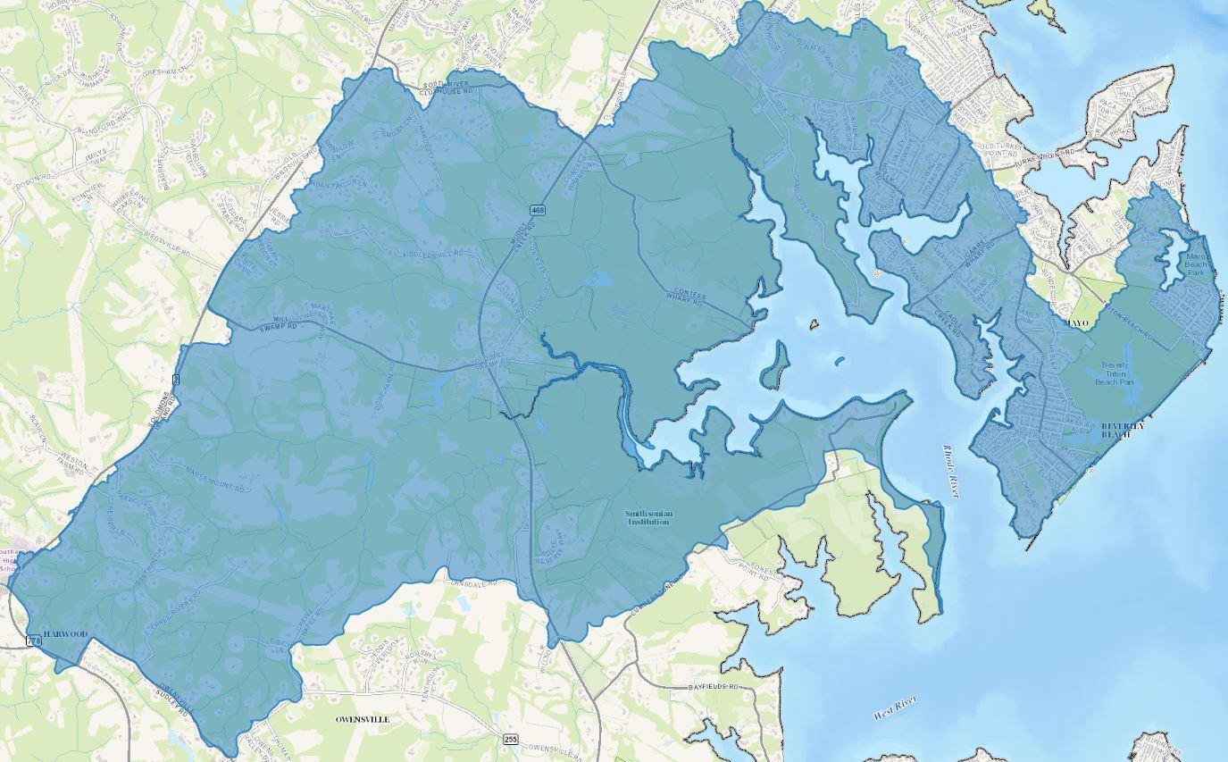
Watershed Description
The Rhode River Watershed is situated in the southeastern portion of the County. It includes the communities of Beverly Beach, Cloverlea, Mayo, Mayo Beach, Clubhouse Estates, South River Estates, Harwood, Mill Swamp, and Java Farms.
The drainage area of the Rhode River Watershed is approximately 8,783 acres and it further divided into 14 sub-watersheds. Major tributaries include Muddy Creek, Sellman Creek and Bear Neck Creek. The Rhode River empties into the West River, which drains directly into the Chesapeake Bay.
Impervious surfaces represented by roads, building footprints, parking lots and other hard surfaces cover approximately 5% (~473 acres) of the Rhode River watershed. Major landmarks include Mayo Beach Park, Beverly Triton Beach Park, Camp Letts and the Smithsonian Environmental Research Center.
Land covered with woods makes up the greatest portion of the Rhode River watershed, approximately 54%. Apart from woods, the other most significant land use/land cover categories are row crop and 2-acre residential.
Watershed Assessment
The Watershed Protection and Restoration Program utilizes a watershed based approach to restoring and protecting our waterways. Assessments are conducted on each of the 12 primary watersheds to evaluate water conditions, establish priorities and goals for improvement, and take actions designed to restore or protect water quality.
A comprehensive watershed assessment for the Rhode River watershed has been completed. The reports include a discussion of the water quality problems and sources of pollution and strategies for improving the water quality in the watershed. Click here to read more.
Local Watershed Organizations
Successful conservation and preservation of Anne Arundel County's watersheds takes teamwork. Here is a list of organizations that work to protect the Rhode River watershed:
Arundel Rivers Federation
Anne Arundel County Watershed Stewards Academy
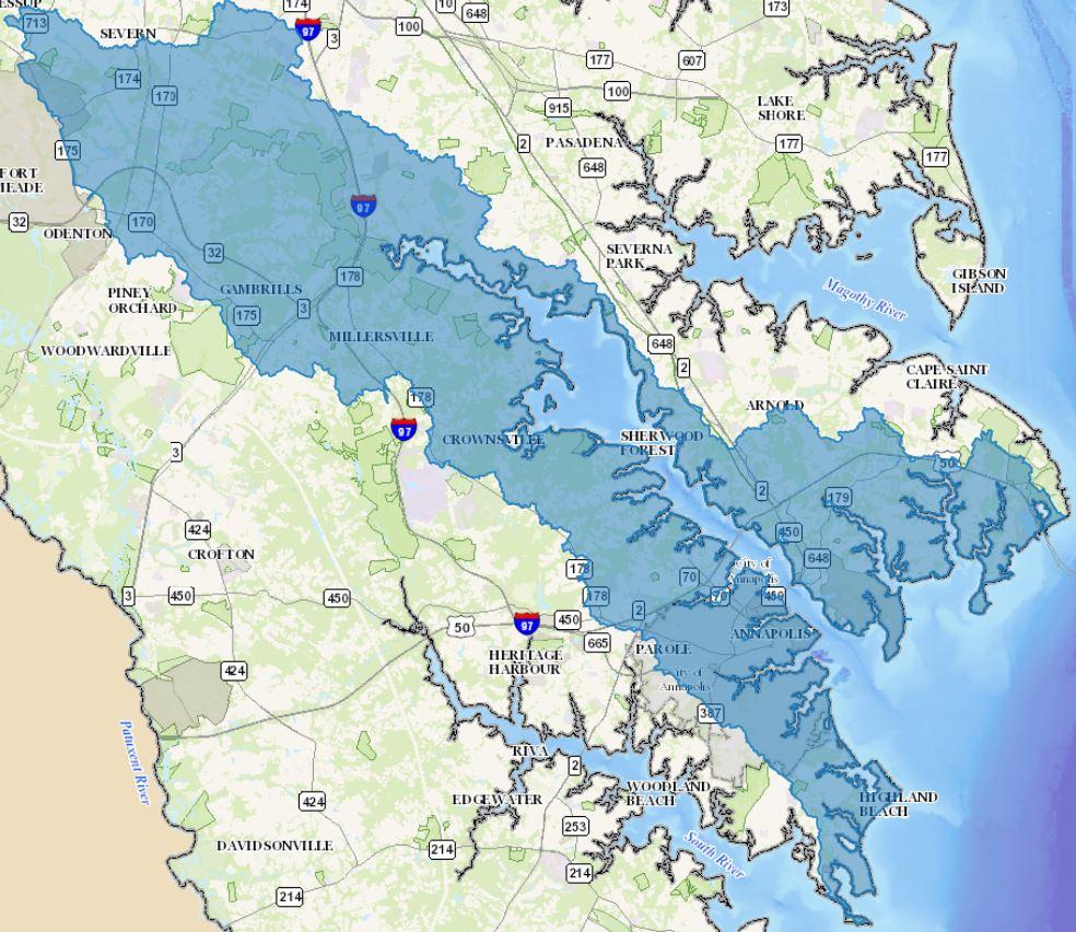
Watershed Description
The Severn River Watershed is situated in the central portion of the County. It includes the communities of Oyster Harbor, Highland Beach, Bay Ridge, Annapolis Roads, Eastport, City of Annapolis, Tidewater Colony, Severn Forest, Epping Forest, Sherwood Forest, Herald Harbor, Cranberry Woods, Crownsville, Millersville, Gambrills, Seven Oaks, Meade Heights, The Provinces, Stillmeadow, Quarterfield Farm, Oakdale, Mill Race, Shipleys Choice, Chartwell, Fair Winds, Old Severna Park, Pine Bluff, Winchester, Capetown, Baydale Estates, Pendennis Mount, Pleasant Plains and Whitehall Manor. In 1971, the Severn River was designated as one of Maryland’s Scenic Rivers.
The drainage area of the Severn River Watershed is approximately 44,248 acres. It contains approximately 152 miles of streams draining 80 sub-watersheds. Major tributaries include Severn Run, Maynadeir Creek, Mill Creek, Weems Creek, Whitehall Creek, Spa Creek, Back Creek. Severn Run and its tributaries make up 63.95 miles of the stream miles in the Severn River Watershed.
Many unique and ecologically important natural features can be found within the borders of this watershed. Within the state of Maryland, Anne Arundel County possesses the highest quantity of freshwater bogs, which qualify as wetlands of special state concern. Bogs within the Severn River Watershed include Arden Bog, Arlington Echo, Cypress Creek, Lakewood, Carrollton, Forked Creek and Sullivan’s Cove. These areas are important as they serve as water filters, improving water quality within the watershed, and creating habitat for rare, threatened and endangered flora and fauna. Jabez Branch, the largest tributary to Severn Run, is the only Coastal Plain stream that supports a naturally reproducing population of brook trout. Jabez Branch has a series of springs and dense forest cover that provide the cool water necessary for brook trout reproduction.
Land use in the watershed is diverse. Portions are highly developed, containing the City of Annapolis, shopping centers, subdivisions, and industrial parks. The single most dominant land use is single family residential, at all densities, at 38%. Forest is next, at 32%. Fifteen percent of the watershed is taken up with commercial and industrial property and the City of Annapolis. Impervious surfaces represented by roads, building footprints, parking lots and other hard surfaces cover approximately 19% (~8,269 acres) of the Severn River watershed.
Major landmarks include US Naval Academy, Annapolis Mall, Millersville Landfill and Resource Recovery Facility, Severn Run Natural Environment Area, Chartwell Country Club and USNA Golf Club. In addition several County Parks are within the borders of the Severn River watershed including Provinces Park, Randazzo Park, Arnold Park, and portions of Broadneck Park and Sandy Point State Park.
Watershed Assessment
The Watershed Protection and Restoration Program utilizes a watershed based approach to restoring and protecting our waterways. Assessments are conducted on each of the 12 primary watersheds to evaluate water conditions, establish priorities and goals for improvement, and take actions designed to restore or protect water quality.
A comprehensive watershed assessment for the Severn River watershed has been completed. The reports include a discussion of the water quality problems and sources of pollution and strategies for improving the water quality in the watershed. Click here to read more.
Local Watershed Organizations
Successful conservation and preservation of Anne Arundel County's watersheds takes teamwork. Here is a list of organizations that work to protect the Severn River watershed:
Severn River Association
Severn Riverkeeper
Severn River Commission
Spa Creek Conservancy
Scenic Rivers Land Trust
Weems Creek Conservancy
Chesapeake Ecology Center
Anne Arundel County Watershed Stewards Academy
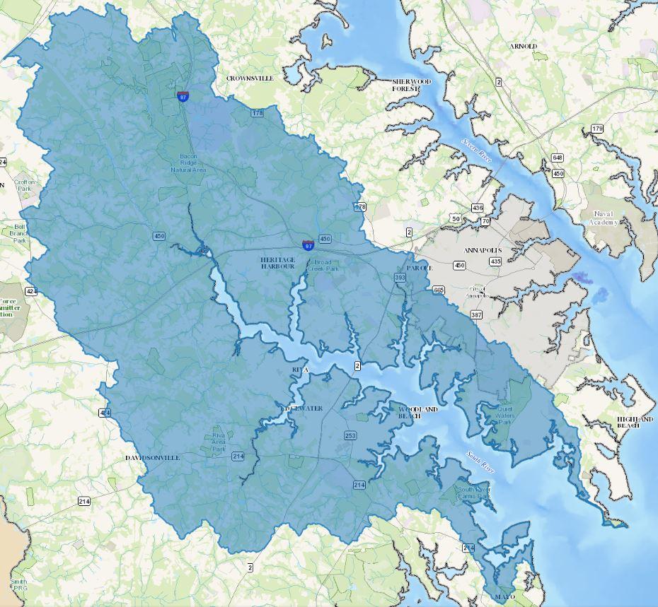
Watershed Description
The South River watershed is located in central Anne Arundel County. It includes the communities of Shoreham Beach, Selby on the Bay, South River Colony, Woodland Beach, Edgewater, Hardesty, Riva, Rutland, Staples Corner, Crofton Meadows, Crofton Farms, The Ridges, Crownsville, Heritage Harbour, Riva Trace, Gingerville, Parole, Annapolis Walk, Wild Rose Shores, Annapolis Overlook, Hunt Meadow, Hillsmere Shores and Fishing Creek Farms.
The drainage area of the South River Watershed is approximately 36,433 acres. It contains approximately 246 miles of streams divided into 59 sub-watersheds. Major tributaries include Broad Creek, Beards Creek, Church Creek, Glebe Creek, Crab Creek and Harness Creek. From its headwaters in Crofton, the river enters the Chesapeake Bay south of the City of Annapolis, hence the name South River.
The land acres are divided as follows: urban 14,251 acres (39%), agriculture 5,472 acres (15%), forest 16,669 acres (46%), wetlands 132 acres (<1%) and barren land 4 acres (<1%). Impervious surfaces represented by roads, building footprints, parking lots and other hard surfaces cover approximately 12% (~4,432 acres) of the South River watershed. Major landmarks in the South River watershed include Annapolis Towne Centre at Parole, Festival at Riva, Annapolis Harbour Center, Eisenhower Golf Course, Anne Arundel County Fairgrounds, Walden Golf Course, Lee Airport and South River Golf Links.
Watershed Assessment
The Watershed Protection and Restoration Program utilizes a watershed based approach to restoring and protecting our waterways. Assessments are conducted on each of the 12 primary watersheds to evaluate water conditions, establish priorities and goals for improvement, and take actions designed to restore or protect water quality.
A comprehensive watershed assessment for the South River watershed has been completed. The reports include a discussion of the water quality problems and sources of pollution and strategies for improving the water quality in the watershed. Click here to read more.
Local Watershed Organizations
Successful conservation and preservation of Anne Arundel County's watersheds takes teamwork. Here is a list of organizations that work to protect the South River watershed:
Arundel Rivers Federation
Anne Arundel County Watershed Stewards Academy
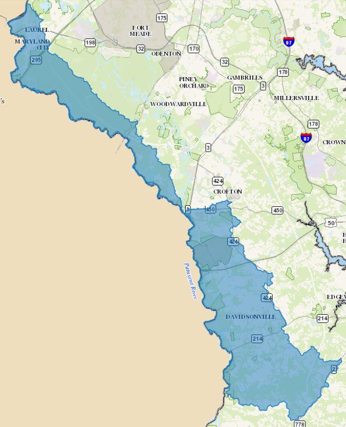
Watershed Description
The Upper Patuxent Watershed in the southwestern portion of the County along a border shared with Prince George’s County. It includes the communities of Laurel, Maryland City, Brockbridge Estates, Parkway Village and Woodwardville.
The watershed is part of Maryland’s Patuxent River basin. The Patuxent River basin drains approximately 900 square miles of land, including portions of Anne Arundel, Baltimore, Calvert, Charles, Howard, Prince George’s, Montgomery, and St. Mary’s Counties.
The portion of the watershed within Anne Arundel County drains approximately 22,590 acres, contains approximately 90 miles of perennial streams and is divided into 19 sub-watersheds. Major tributaries include Davidsonville Branch and Stocketts Run.
Impervious surfaces represented by roads, building footprints, parking lots and other hard surfaces cover approximately 6% (~1,263 acres) of the Upper Patuxent watershed. A large portion of the northern section of the watershed contains the Patuxent Wildlife Research Center. Other major landmarks include Laurel Park, Renditions Golf Course and several County parks including Bell Branch Park, Davidsonville Park, Patuxent River Park and Riverwood Park.
Watershed Assessment
The Watershed Protection and Restoration Program utilizes a watershed based approach to restoring and protecting our waterways. Assessments are conducted on each of the 12 primary watersheds to evaluate water conditions, establish priorities and goals for improvement, and take actions designed to restore or protect water quality.
A comprehensive watershed assessment for the Upper Patuxent watershed has been completed. The reports include a discussion of the water quality problems and sources of pollution and strategies for improving the water quality in the watershed. Click here to read more.
Local Watershed Organizations
Successful conservation and preservation of Anne Arundel County's watersheds takes teamwork. Here is a list of organizations that work to protect the Upper Patuxent watershed:
Patuxent Riverkeeper
Scenic Rivers Land Trust
Anne Arundel County Watershed Stewards Academy
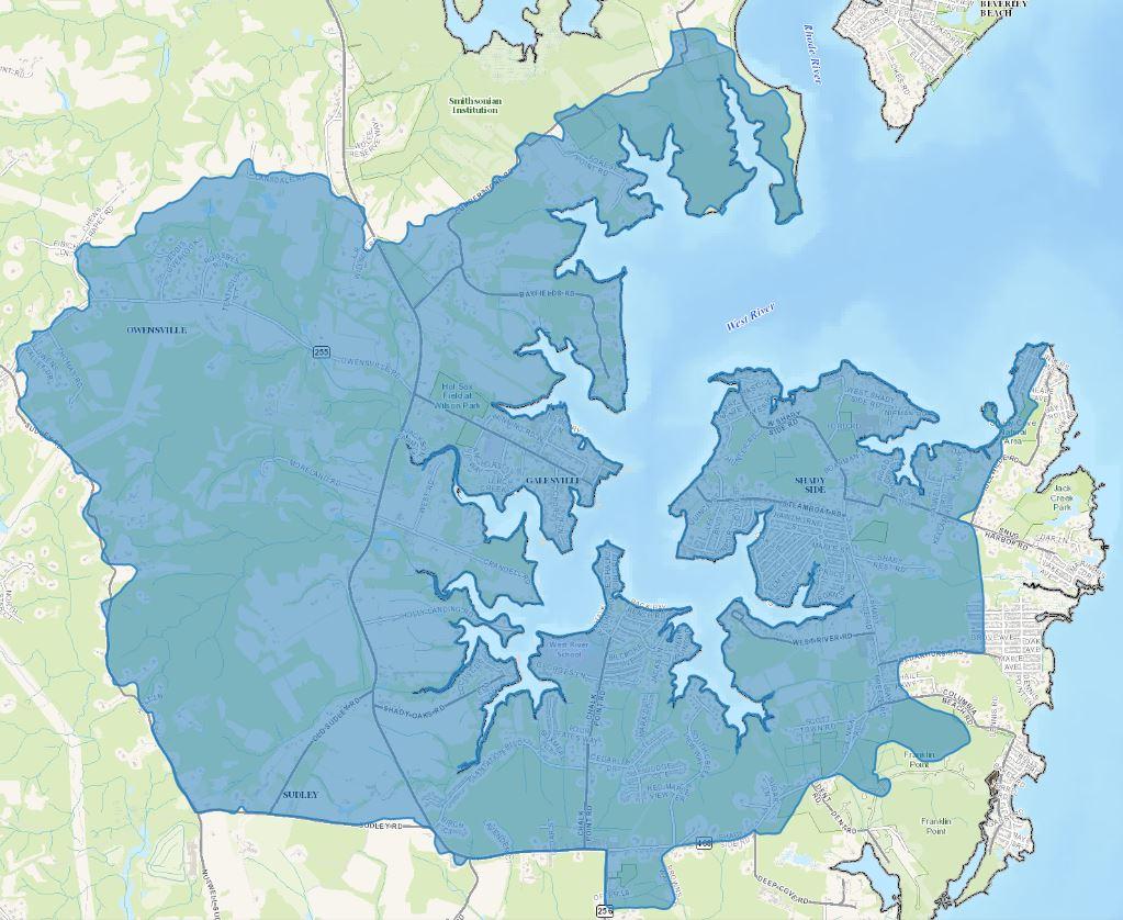
Watershed Description
The West River Watershed is situated in the southeastern portion of the County. It includes the communities of Cumberstone, Owensville, Galesville, Beverly Beach, Sudely, West River, Chalk Point, Cedarlea, Avalon Shores, Shady Side, Idlewilde and Oakland.
The drainage area of the West River Watershed is approximately 7,809 acres. It is divided into 13 sub-watersheds. Major tributaries include South Creek, Lerch Creek, Tenthouse Creek, Popham Creek, Scaffold Creek, Cheston Creek, Smith Creek and Johns Creek. The Rhode River empties into the West River, which drains directly into the Chesapeake Bay.
Impervious surfaces represented by roads, building footprints, parking lots and other hard surfaces cover approximately 6% (~492 acres) of the West River watershed.
Land covered with woods makes up the greatest portion of the West River watershed, approximately 44%. Apart from woods, the other most significant land use/land cover categories are row crop and 2-acre residential.
Watershed Assessment
The Watershed Protection and Restoration Program utilizes a watershed based approach to restoring and protecting our waterways. Assessments are conducted on each of the 12 primary watersheds to evaluate water conditions, establish priorities and goals for improvement, and take actions designed to restore or protect water quality.
A comprehensive watershed assessment for the West River watershed has been completed. The reports include a discussion of the water quality problems and sources of pollution and strategies for improving the water quality in the watershed. Click here to read more.
Successful conservation and preservation of Anne Arundel County's watersheds takes teamwork. Here is a list of organizations that work to protect the West River watershed:
Arundel Rivers Federation
Anne Arundel County Watershed Stewards Academy