Site Selected
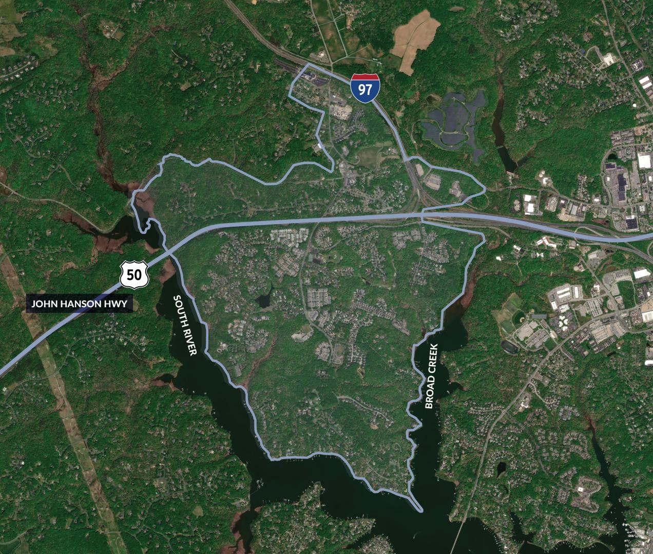
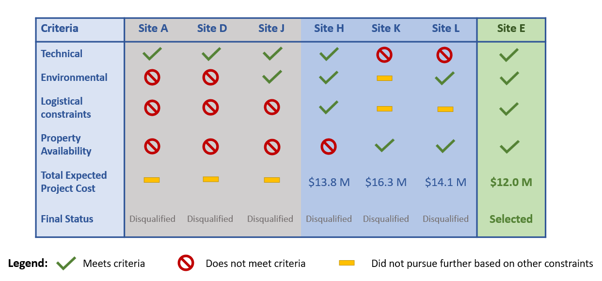
Based on exhaustive technical findings, Site Location E (the Moose Lodge property at 1890 Crownsville Road) has been identified as the most feasible location for the new water tank. This site for the new water tower was carefully selected to meet critical engineering needs, ensure an efficient construction timeline, and remain fiscally responsible for ratepayers. The County balances technical requirements with community input to provide reliable infrastructure for the future.
Recognizing the community's concerns, the County paused the project for over a year to conduct extensive listening sessions and gather vital public feedback. The County made significant financial investment ($250,000) in community engagement and additional engineering evaluations. After this additional phase of thorough evaluation, the data confirms that the originally proposed location remains the most technically feasible and fiscally responsible option.
During the project pause material costs increased and the estimated construction costs have risen from an estimated $7.7M (June 2025) to approximately $11.2M, representing a 45% increase over the last year. This tank is a critical infrastructure project essential to our community's long-term water security and we must move forward without further delay to safeguard the roughly 3,300-resident community within the pressure zone.
Community feedback indicated a primary preference for Site L (Annapolis Waterworks). Site L is at a disadvantage for fire flow due to distance from the demand center of the pressure zone, and it requires the most underground piping, all of which would create the most expensive operating costs with diminished effectiveness.
Community feedback indicated secondary preferences of Site E, K, and H.
Site K (2000 Windermere Ct) is near Site L and would require similar piping lengths, resulting in similar hydraulic challenges to Site L. Furthermore, the transmission mains required for Sites K and L are both expected to cost approximately $2M to $4.5M more than Site E.
Site H (534 Defense Hwy) is near the commercialized intersection of Defense Hwy & Crownsville Rd and is hydraulically suitable. However, the County experienced land acquisition challenges and the total project cost is expected to be approximately $2M more than Site E due to increased land costs and the requirement of a taller tank.
The County values community input and relies on public feedback and participation in many capital investments. The decisions on where to locate critical infrastructure, such as utilities, must pair public feedback with specialized technical expertise to deliver the safest and most efficient utility services possible.
Site Evaluation Results
Site Survey & Feedback
As the County was evaluating the best possible solution for the location of the new Elevated Water Storage Tank, we invited residents to share feedback, questions and comments via a printed and digital survey distributed as part of DPW’s Open Houses on October 28 and 29, 2025.
Survey results were compiled including all respondents' feedback submitted at the open houses and collected through November 14, 2025. The digital survey was closed at 12:00 a.m. on November 15, 2025. A summary of results is provided below, as well as the full survey report and individual comment responses located on the Meeting Notes webpage. Survey results were compiled via a third-party consultant.
Total Survey Responses: 264
Elevated Water Storage Tank Site Selection Criteria (Ranked from 1-5, 1 is highest priority):
Question: When choosing a site for the tank, how would you like the County to prioritize the site selection criteria?
- Impact to Personal Property Values
- Tank Visibility and Aesthetics
- Environmental Impacts
- Construction Noise and Traffic
- Cellular Tower Potential
Consideration Factors for the Elevated Water Storage Tank (Ranked from 1-3, 1 is most important):
Question: Which of the following factors are most important to you for the Heritage Harbour Elevated Water Storage Tank?
- Reliable Water Service
- Fire Protection and Safety
- Minimizing Visual Impacts
Site Locations Public Respondent Feedback:
Question: Of the location options currently under review, which site would you prefer for the Elevated Water Storage Tank? (DPW will incorporate the community's preference to the maximum extent possible but cannot guarantee any site chosen.) (Options ranked from 1 = most preferred to 7 = least preferred)
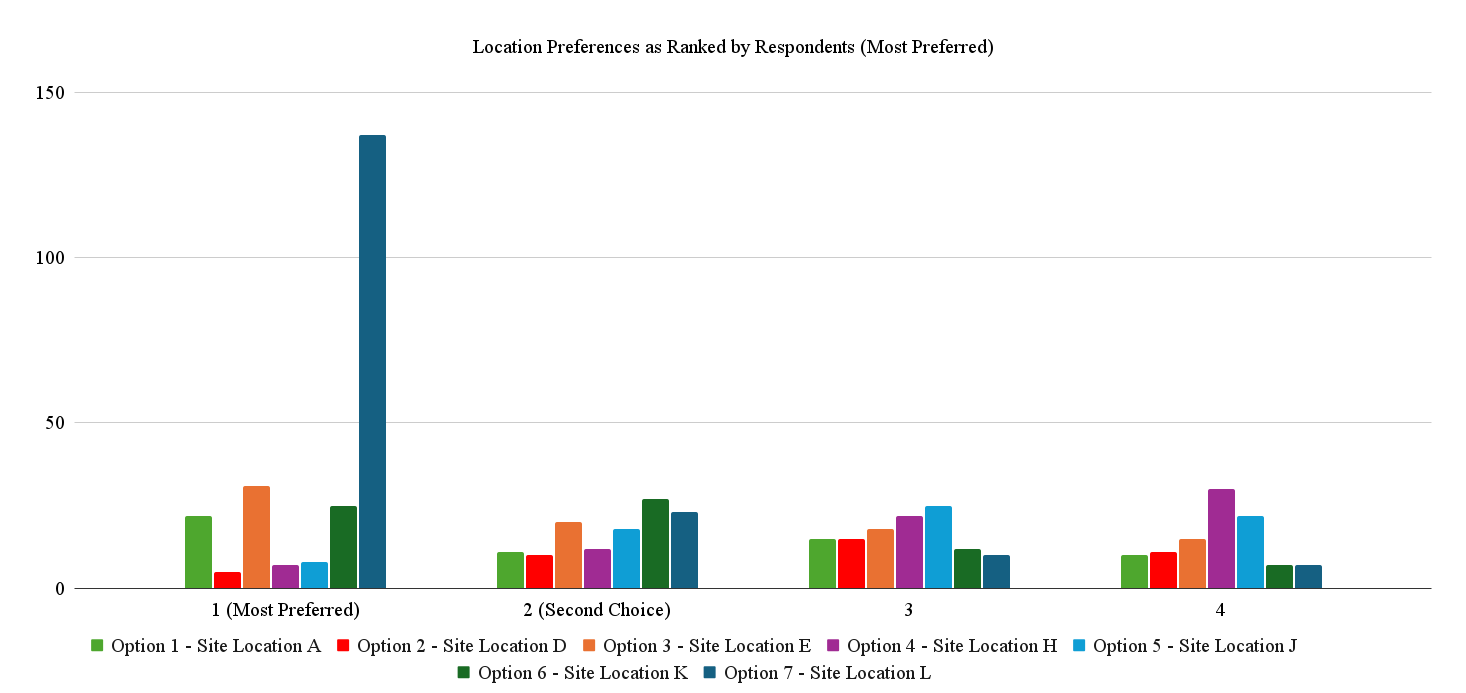
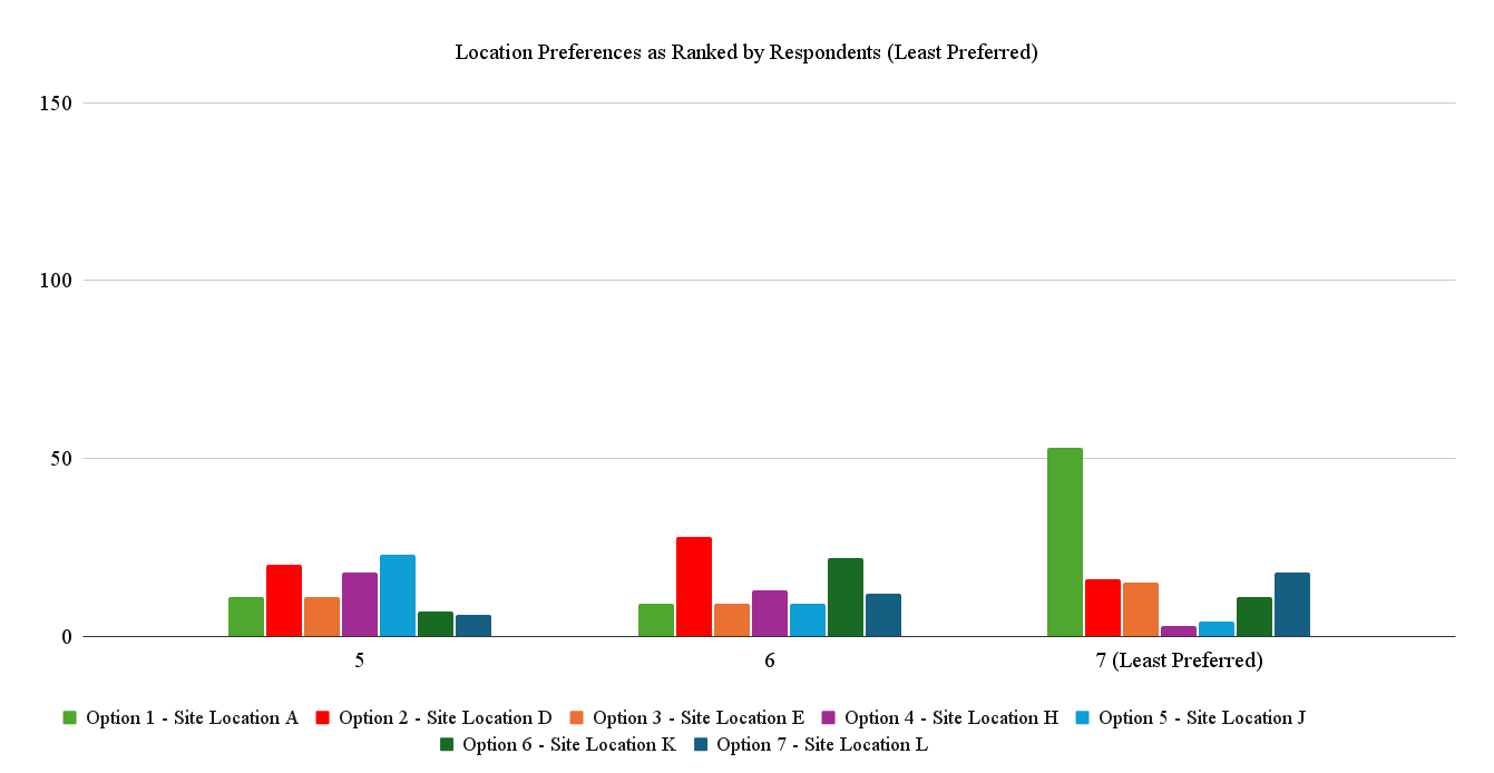
Option 1 Site Location A: Approximately 960 Bermuda Lane, Annapolis, MD 21401
Option 2 Site Location D: 427 Ashers Farm Road, Annapolis, MD 21401, adjacent open lot
Option 3 Site Location E: 1890 Crownsville Road, Annapolis, MD 21401
Option 4 Site Location H: 534 Defense Highway, Crownsville, MD 21032
Option 5 Site Location J: 1907 & 1909 Crownsville Road, Annapolis, MD 21401
Option 6 Site Location K: 534 Defense Highway, Crownsville, MD 21032
Option 7 Site Location L: Open space off North River Road, Annapolis, MD 21401
For complete survey results, click here.
(Referenced as “common responses” within the comment response sheet)
Q1: Why aren’t booster pump systems being considered as an alternative?
A1: Refer to the FAQ page for the question “What alternatives exist outside of building a new Elevated Water Storage Tank?” In the long term, an Elevated Water Storage Tank is the more efficient and reliable option, both operationally and economically, and offers benefits that additional pumps cannot, such as reliable fire protection with redundancy.
Q2: Why is Site C (7 Harry S Truman Parkway) no longer under consideration? It is County-owned land.
A2: The County removed this site from consideration upon review of the location’s Schematic Design Report (2015), which notes the site being remote from the demand center, requiring a parallel transmission main for redundancy, as well as requiring significant pumping improvements. Site I has similar limitations.
Q3: Why isn’t there cost information for consideration, shouldn’t taxpayers be informed with cost estimates to make this decision?
A3: The EWST program (W799600) is funded by drinking water utility rates, not taxes. The County plans to develop cost estimates for the top-rated site(s), which requires further investigation. The project cost is expected to be directly related to the height of the tank, the length of the water main connections, and land acquisition costs.
Q4: We are concerned about impacts to our property values and the neighborhood's aesthetic character.
A4: The County’s goals are to deliver reliable water service and enable fire protection operations, which are in the best interest of the community. Screening for aesthetics will be considered for any location chosen.
Q5: A water tower collapsed in LaPlata, MD and we are concerned that the tower could fall or rupture and flood our properties.
A5: While it’s true that a 100-year old water tower failed in LaPlata, MD, that was a result of the 2002 F4 tornado event. The tank design was antiquated, and the tank reportedly sat empty and had single bolts holding the steel legs to the concrete foundations. The three fatalities and 100 injuries noted by the respondent were entirely unrelated to the water tower falling and occurred in different locations as a result of one of the worst storms to historically impact the DMV area.
Please see the FAQ page for the question “I’ve heard these things can leak or fail. What’s the plan if something goes wrong?” Properly installed and maintained tanks are not prone to failure. The County manages and maintains 31 Elevated Water Storage Tanks and there is no record of leaks at any of these facilities. The County maintains a regular maintenance schedule for all tanks in accordance with recommended guidelines, including coatings to prevent corrosion. Modern elevated water tanks are installed across the country, including in areas prone to extreme weather and earthquakes, with an excellent track record of safety.
Q6: What is the plan for replacing the transmission main and/or backfeeding the area?
A6: DPW is investigating redundancy options for the pressure zone, including backfeeding the area and potentially replacing the transmission main on Truman Parkway. The water distribution project will be coordinated with the final tank location to ensure a complete infrastructure solution.
Q7: Why are you showing sites as viable when the land doesn’t appear to be for sale?
A7: Land availability frequently changes because of the nature of property ownership. The intent was to cast a broad net to identify all technically feasible sites, then negotiate for land availability as appropriate. This method is intended to maximize chances for an equitable selection process.
Q8: Is the increasing development of Riva Road the driver for more water storage needs?
A8: Riva Road is not within the Heritage Harbour Water Pressure Zone. Refer to the FAQ page for the question “We haven’t had an Elevated Water Storage Tank here, so why do we need one now?” The construction of an Elevated Water Storage Tank (EWST) is not a “new” need and has been recommended in the Heritage Harbour Water Pressure Zone dating back to the County’s 2003 Comprehensive Water Strategic Plan. The absence of an EWST resulted in five widespread outages in the last decade. The EWST is needed for improved reliability, redundancy and firefighting capacity.
Project Background
The Heritage Harbour Water Pressure Zone is a subzone of the Broad Creek Water Pressure Zone and is currently supplied with water through a single water main running along Harry S. Truman Parkway. Due to the area's higher elevation than the Broad Creek Water Pressure Zone, the Heritage Harbour Booster Pumping Station maintains pressure in the subzone.
The booster pumping station contains a 12,000-gallon tank used to provide a steady operational water pressure. This means that the Heritage Harbour Water Pressure Zone has no additional water storage, making it one of three water pressure zones in the County without storage in its system. For context, the other pressure zones within Anne Arundel County have a minimum of 70 gallons of water storage per person served.
Over the last 11 years, there have been five breaks in the water main along Harry S. Truman Parkway. The most recent caused a water outage for approximately 2,300 households. Water main breaks cause system disruptions, outages and pose safety concerns for firefighting capacity and water access when there is no backup water storage.
Learn more about water system operations:
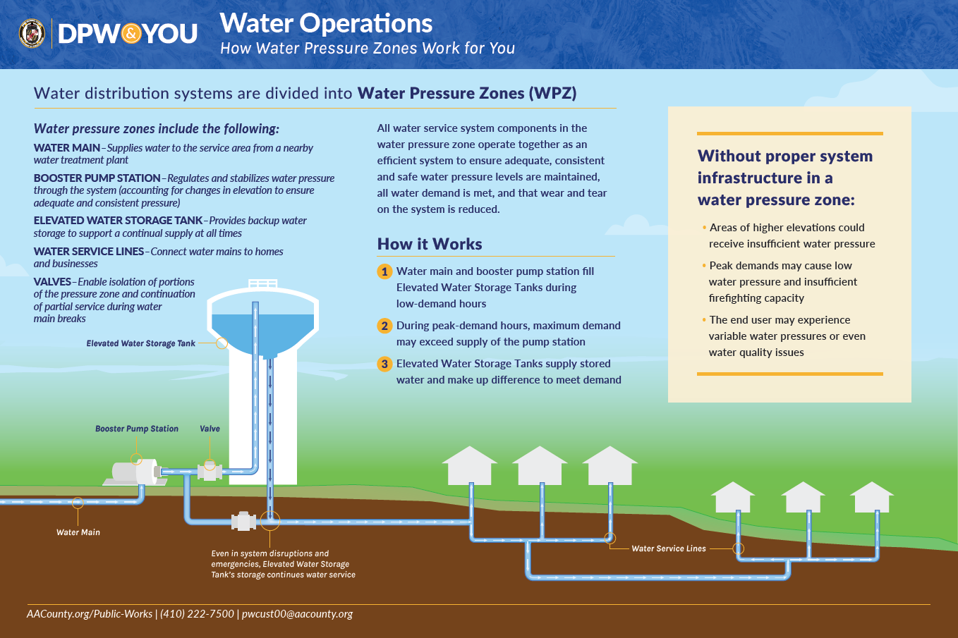
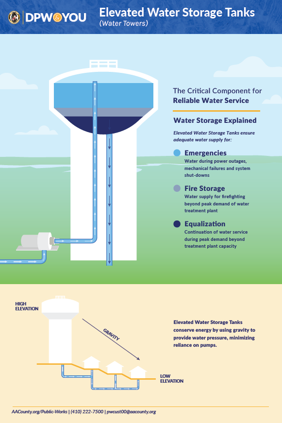
The proposed Elevated Water Storage Tank would provide water storage for the Heritage Harbour pressure zone to ensure an adequate water supply for emergencies, firefighting and water system equalization:
- Emergencies – water during power outages, water main breaks and system shutdowns
- Fire Storage – water supply for firefighting reliably available and in sufficient capacity.
- Equalization – continuation of water service during peak hours beyond treatment plant capacity, and reduction of pumping costs.
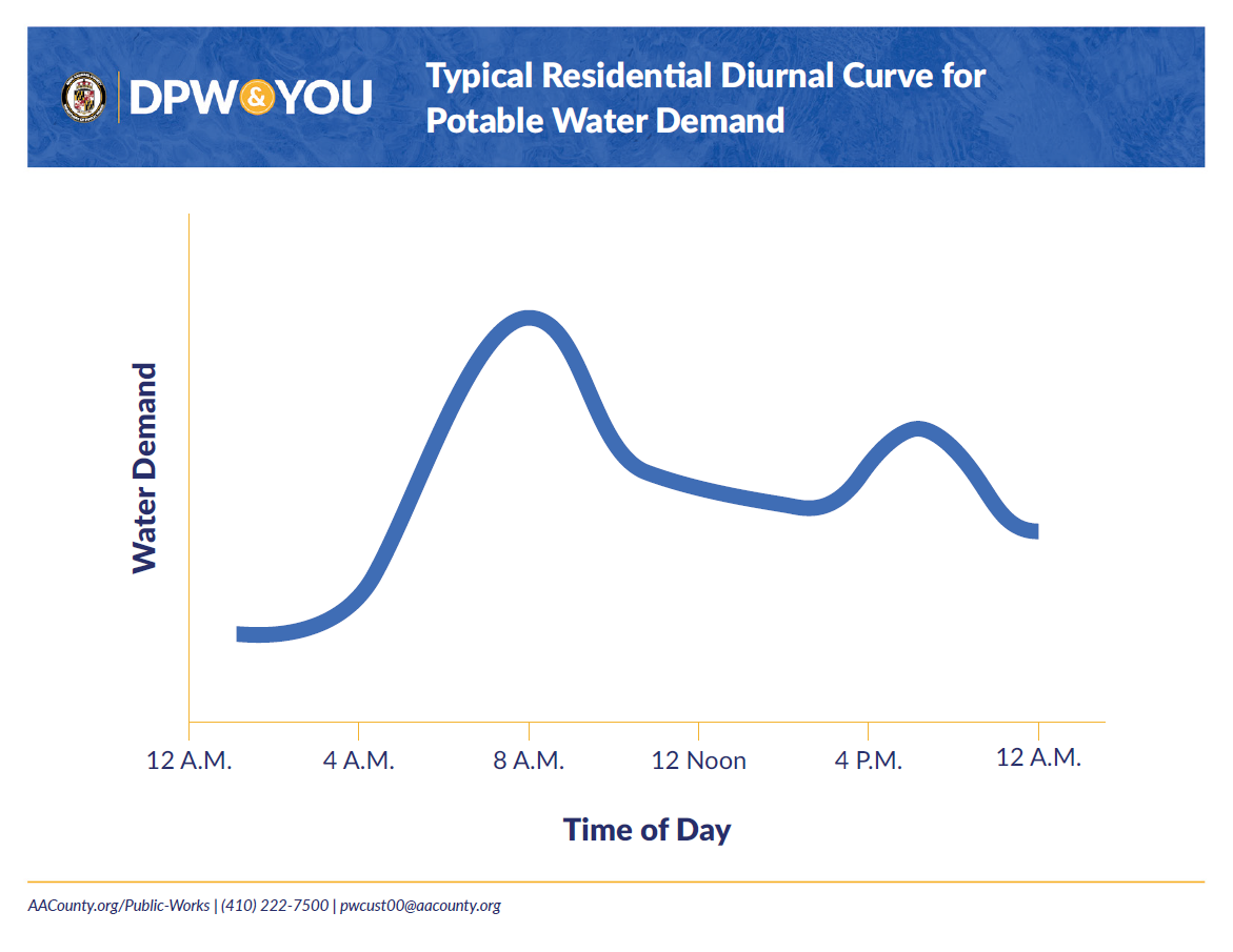
Equalization of the water system is desirable due to how water demand changes throughout the day and week. Water demand in residential areas fluctuates on a diurnal curve, as seen below. For example, there is a sharp rise in demand in the morning as residents prepare for the day, and a second peak in the evening while people prepare dinner and perform household duties. There is low demand at night while most residents are asleep, which is our opportunity to pump water into storage tanks to prepare for tomorrow’s needs.
Site Evaluation Process
The Department of Public Works began an extensive review process in 2013 for potential sites for the construction of the new Elevated Water Storage Tank. Over the past 12 years, the County reviewed 12 different locations to evaluate viability as a potential site. The minimum standards for a site to meet technical viability include:
- Ground surface elevation: Target of 145 feet; minimum of 100 feet +/-
- Tank height: Maximum of 200 feet +/-
- Target length of connection to water main: Less than 5,000 feet from Elevated Water Storage Tank
- Land parcel size: Minimum of 1.5 acres
- Environmental considerations: No floodplain; no steep slopes; not in a critical area
- Property: Must be available for sale to the County
- Tank overflow elevation: 285 feet
- Top of tank elevation: 300-305 feet
Additional criteria considered during the evaluation process are: accessibility for service, historical or archaeological impacts, environmental impacts, land plans, proximity to airports, construction requirements and capital costs, and balance of the water pressure zone.
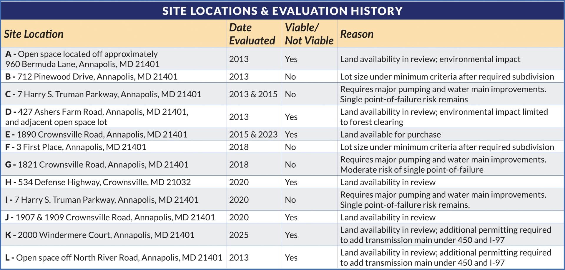
Previously Considered Site Options
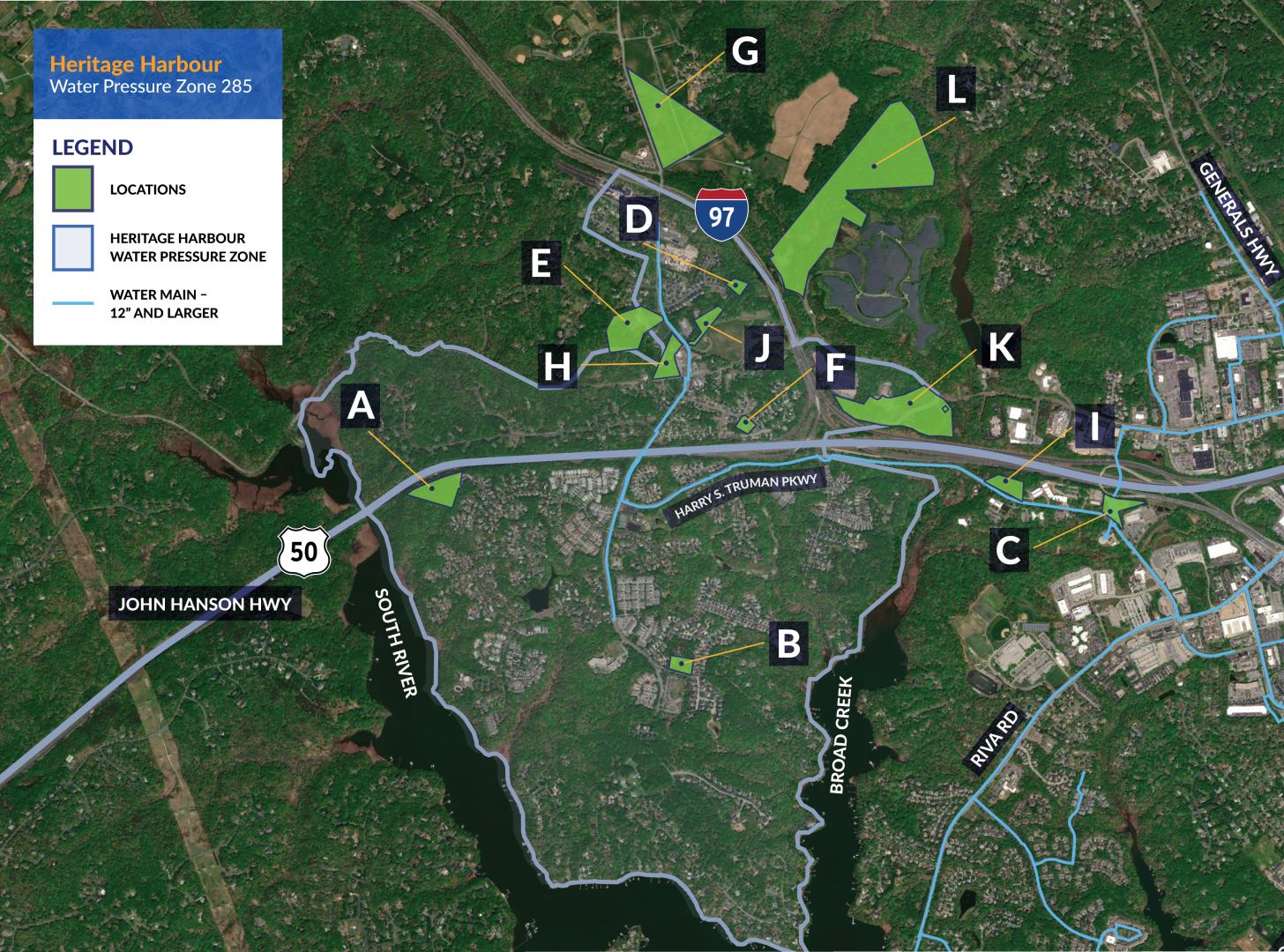
The following sites were considered and site E was found to be the most feasible and cost effective.
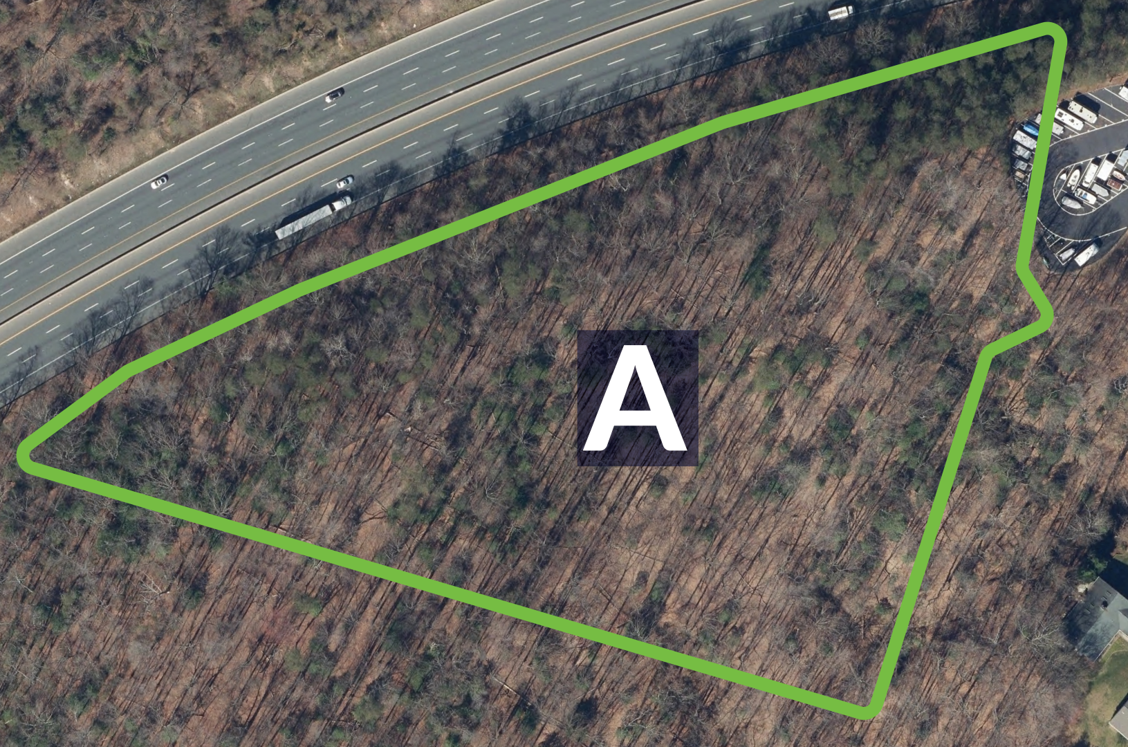
Option 1: Site Location A
Approximately 960 Bermuda Lane,
Annapolis, MD 21401 (NO OFFICIAL ADDRESS)
Considerations:
- Tank height: 165 ft. +/-
- Water main connection: 3,500 ft.
- Visual impact: Low-moderate
- Environmental impacts: Moderate-high (forest stand impacts; limited steep slopes)
- Land availability status: In review
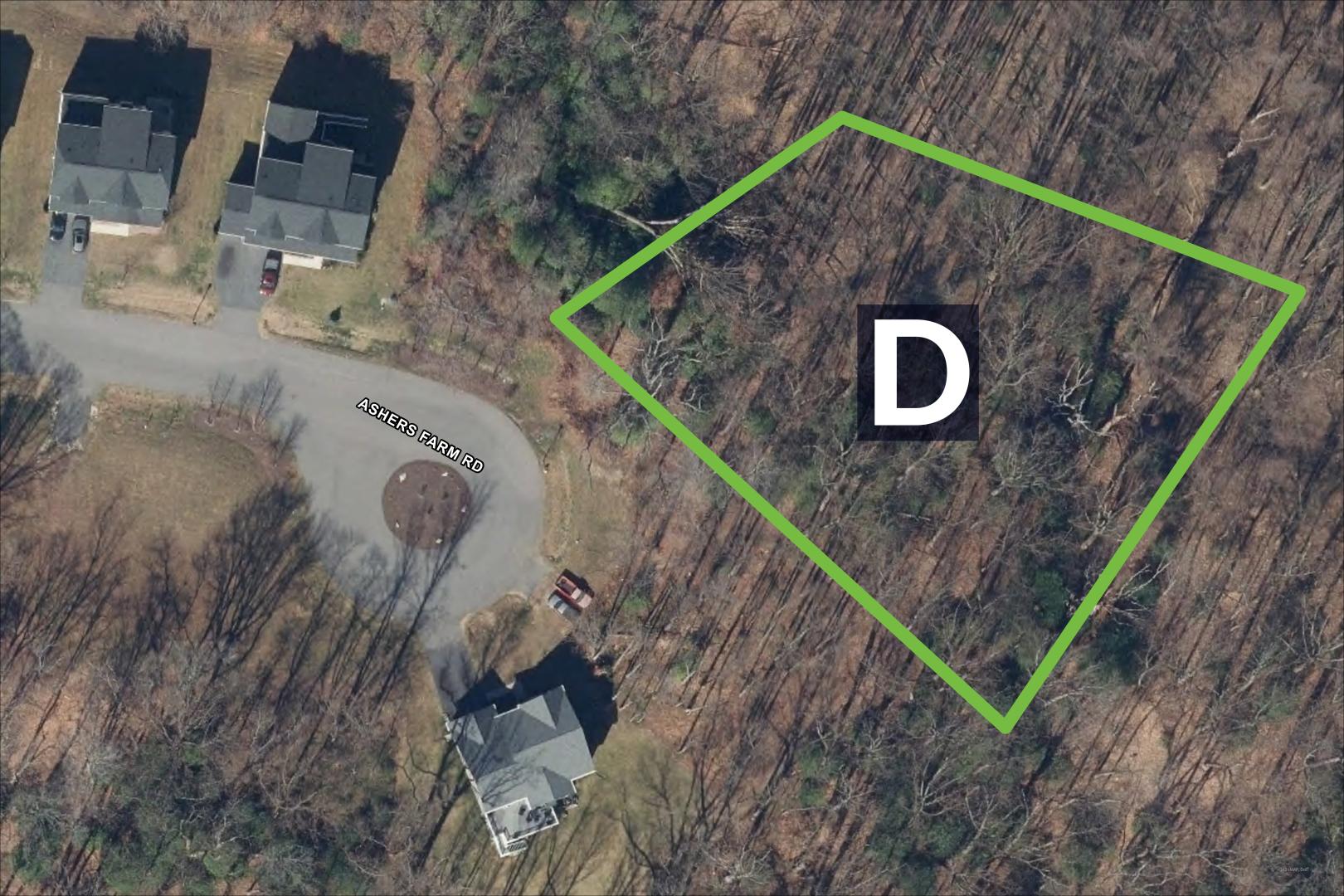
Option 2: Site Location D
427 Ashers Farm Road,
Annapolis, MD 21401 (and adjacent open space lot)
Considerations:
- Tank height: 200 ft. +/-
- Water main connection: 2,000 ft.
- Visual impact: Low-moderate
- Environmental impacts: Moderate (forest stand impacts; limited steep slopes)
- Land availability status: In review
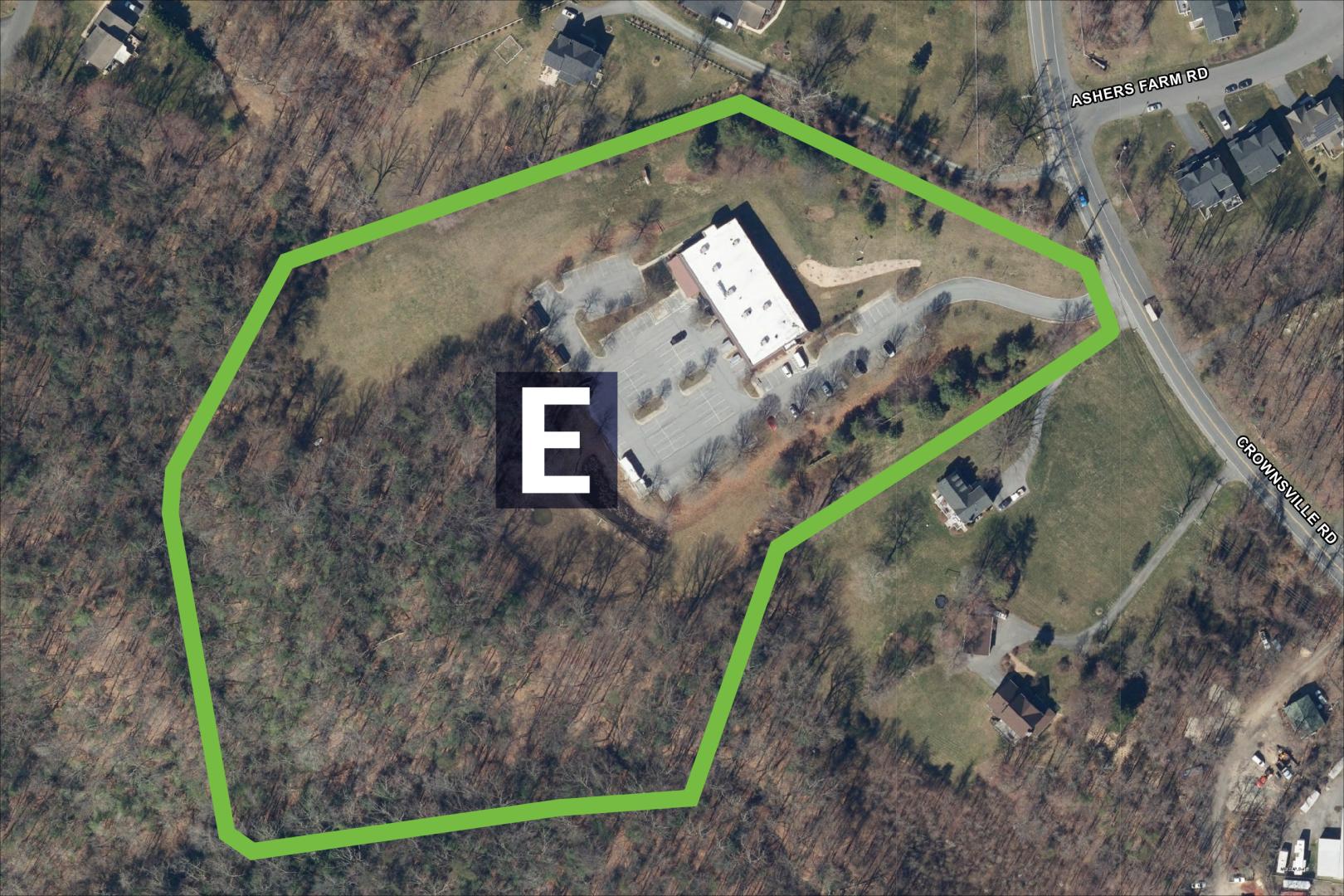
Option 3: Site Location E
1890 Crownsville Road,
Annapolis, MD 21401
Considerations:
- Tank height: 200 ft +/-
- Water main connection: 1,000 ft
- Visual impact: Moderate-High
- Environmental impacts: Low (site is largely cleared)
- Land availability status: Ready for acquisition
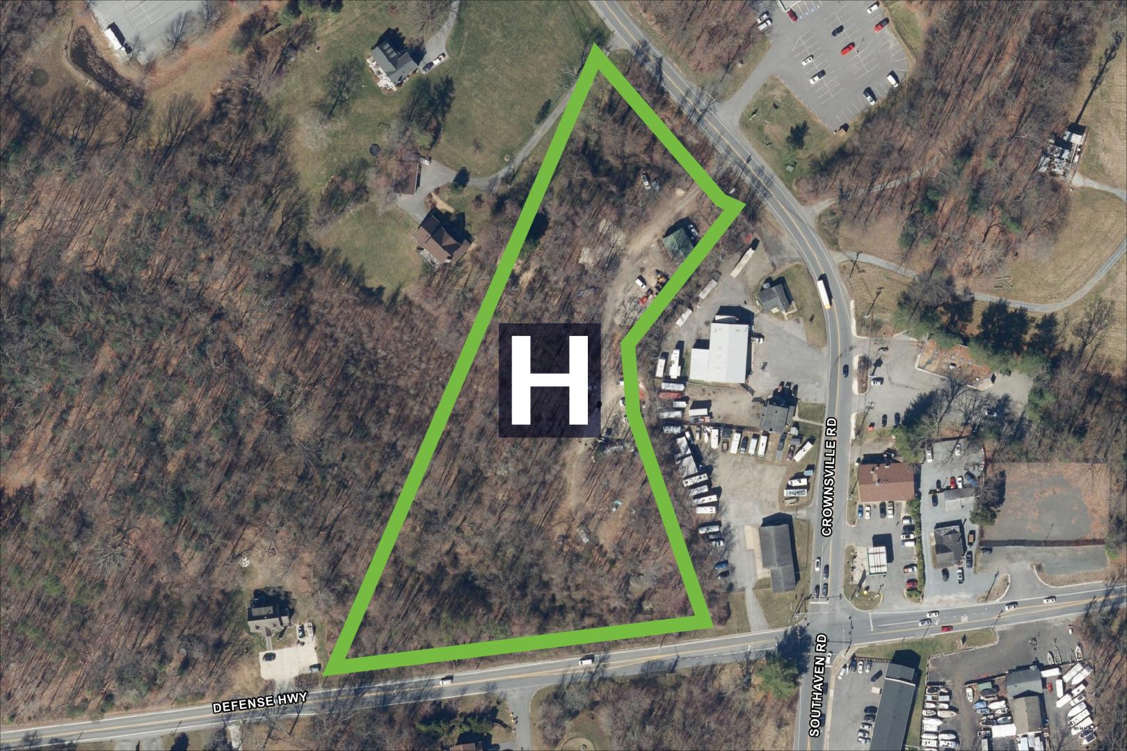
Option 4: Site Location H
534 Defense Highway,
Crownsville, MD 21032
Considerations:
- Tank height: 200 ft +/-
- Water main connection: 800 ft
- Visual impact: Moderate
- Environmental impacts: Moderate (some clearing required adjacent to stream tributary)
- Land availability status: In Review
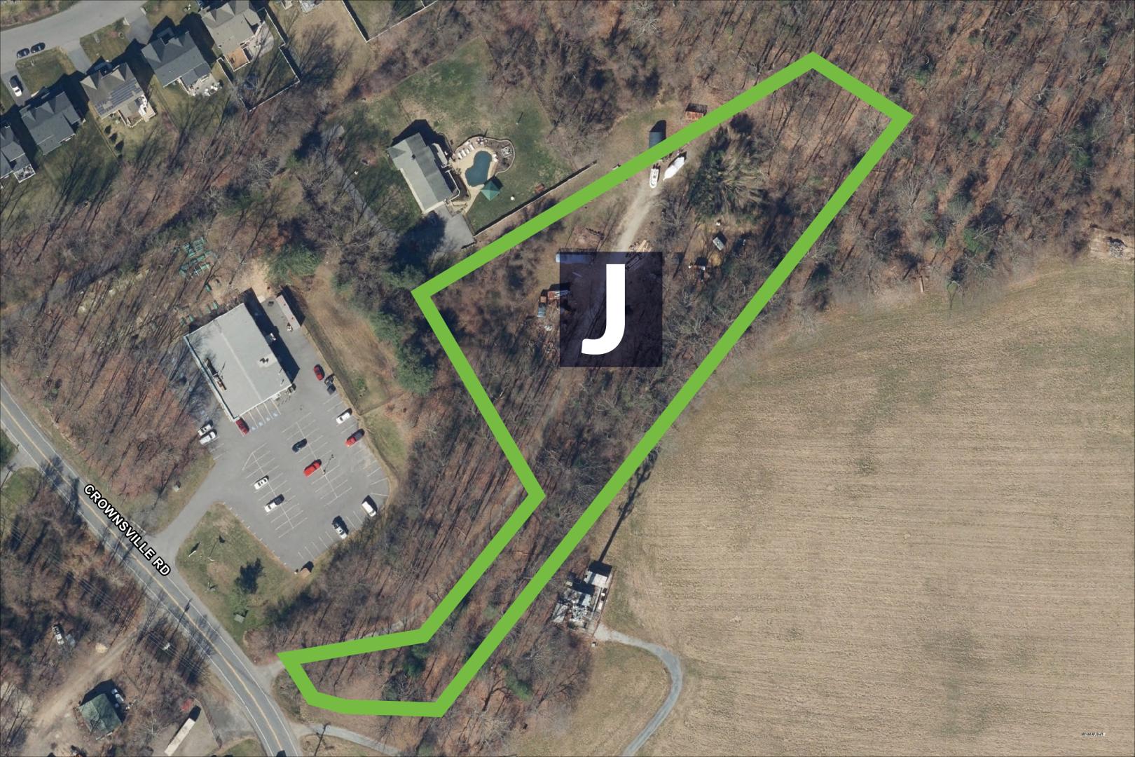
Option 5: Site Location J
1907 & 1909 Crownsville Road,
Annapolis, MD 21401
Considerations:
- Tank height: 200 ft +/-
- Water main connection: 600 ft
- Visual impact: Moderate
- Environmental impacts: Low-Moderate
- Land availability status: In Review
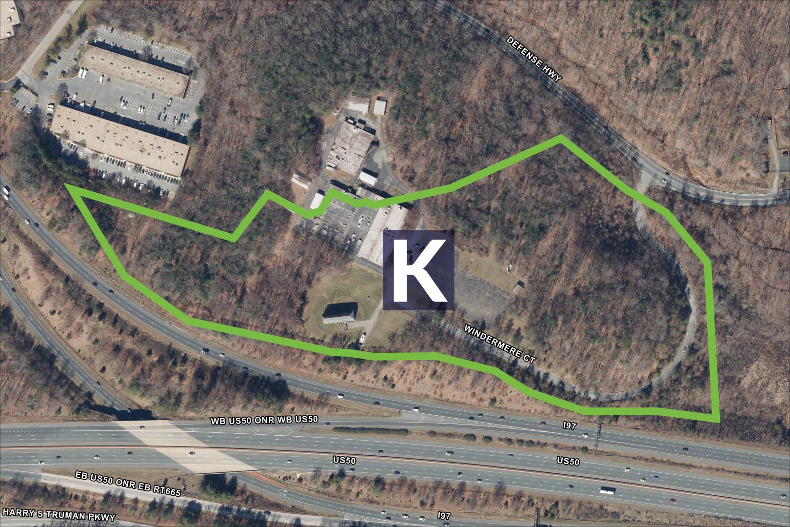
Option 6: Site Location K
2000 Windermere Court,
Annapolis, MD 21401
Considerations:
- Tank height: 180 ft. +/-
- Water main connection: 5,500 ft.
- Visual impact: Low
- Environmental impacts: Low
- Land availability status: In Review
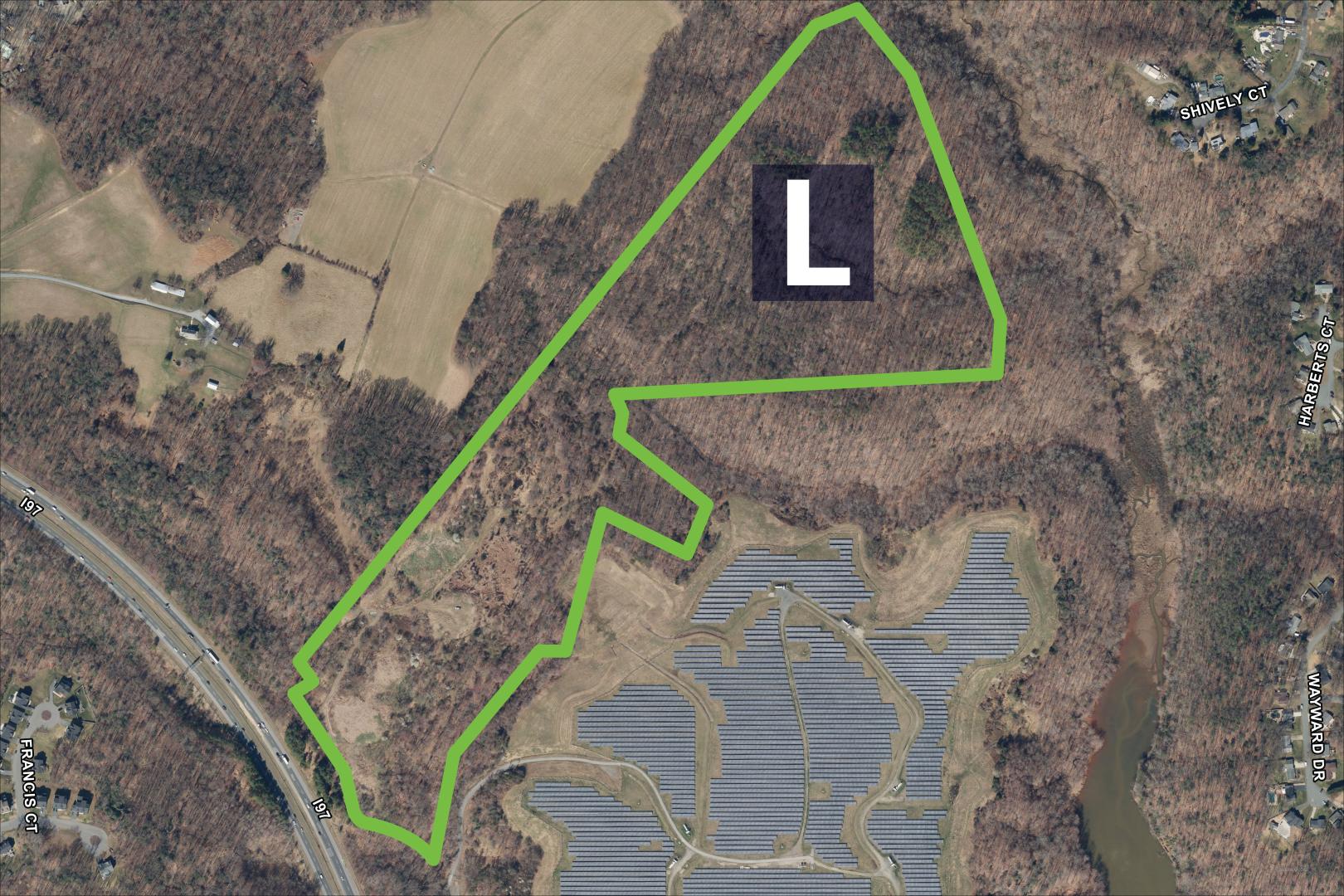
Option 7: Site Location L
Open space off North River Road,
Annapolis, MD 21401
Considerations:
- Tank height: 190 ft. +/-
- Water main connection: 5,000 ft.
- Visual impact: Low
- Environmental impacts: Low
- Land availability status: In review
Project History/Timeline
-
Project planning & initiation
2012
-
Public Meeting: Presentation of site options
September 2013
-
Site locations evaluations
Fall 2013 - Present
-
Public Meeting: Presentation of site options
March 2025
-
Public Meeting(s): Elevated Water Storage Tank Open House Informational Poster Session
October 2025
-
Current Status
Site selected and project resumed
-
Estimated Completion
March 2029