| Time Frame | BIBI (Condition)a | FIBI (Condition)ab | RBP (Condition) |
|---|---|---|---|
| 2024 Results | 3.29 (Fair) | 1.67 (Very Poor) | 144 (Supporting) |
| Cumulative Average (2005-2024) | 3.47 (Fair) | 2.94 (Fair) | 151 (Comparable) |
| 3-year Running Average | 3.86 (Fair) | 2.67 (Fair) | 151 (Comparable) |
a. No data for 2006.
b. Fish data were collected in 2015, 2016, 2018, 2020, 2022, and 2024.
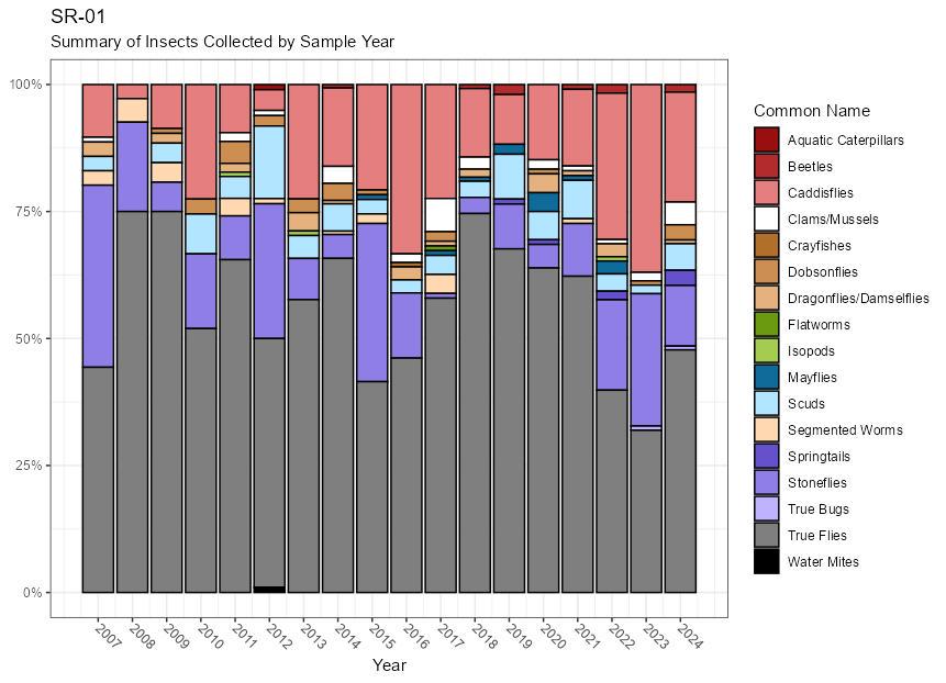
In 2024, SR-01 received a BIBI score of 3.29 (Fair). Biological conditions at this station have been typically rated as “Fair”, with a long-term average BIBI score of 3.47 and a three-year average score of 3.86. Caddisflies and stoneflies made up over 1/3rd of the sample. Mayflies were absent from the 2024 sample for the second year in a row, however, dobsonflies were present in the sample for the second year in a row.
SR-01 Summary of Insects Collected by Sample Year:
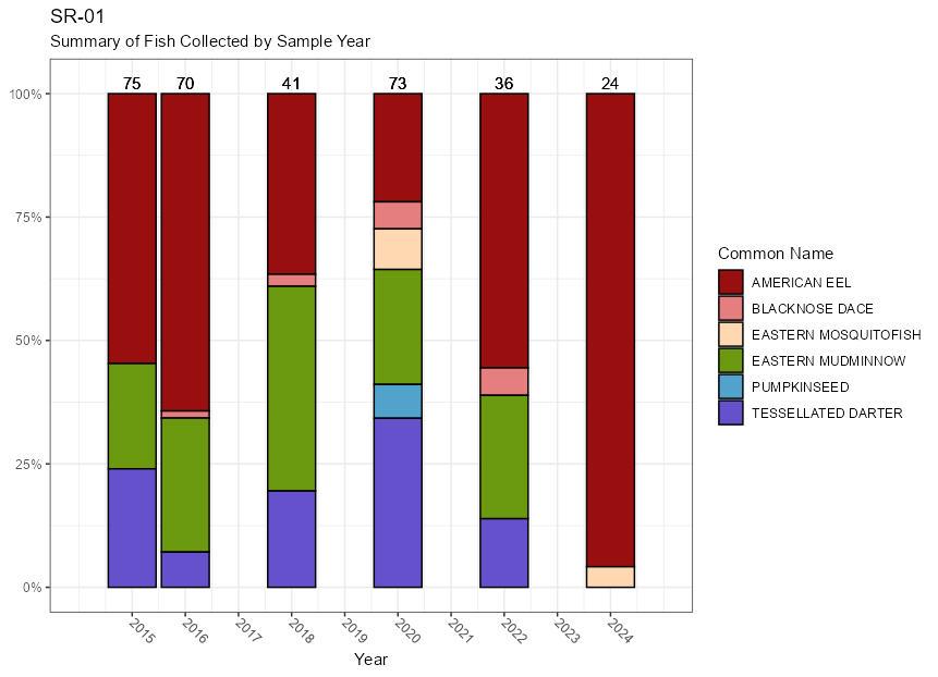
In 2024, a FIBI value of 1.67 (very Poor) was obtained in this reach. This site has been rated “Fair” in all five prior years that fish sampling has occurred. Two species were observed at this location in 2024: American eel (Anguilla rostrata) and eastern mosquitofish (Gambusia holbrooki).
SR-01 Summary of Fish Collected by Sample Year:
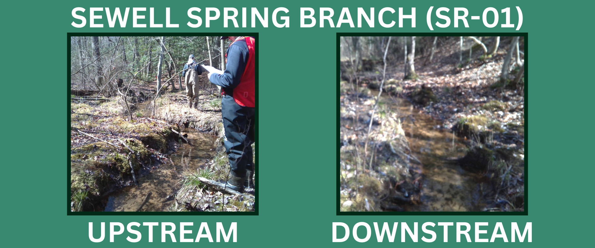
This site received an RBP score of 144 (Supporting) in 2024. Habitat condition scores at the site have been consistently high since assessments began in 2005, with a cumulative average RPB score of 151. High quality epifaunal substrate (structures on the streambed that provide surfaces on which animals can live), a variety of flow features, low banks, and a broad forested riparian area all contribute to the excellent habitat conditions found at the site.
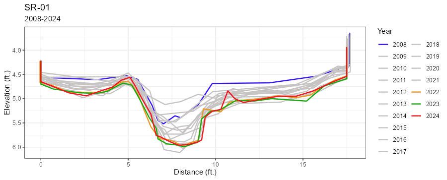
Little change was observed from 2008 to 2010. The channel steadily incised between 2012 and 2020, resulting in a drop in water surface elevation of approximately 0.70 feet over that time. In 2021 the channel began to experience aggradation again, increasing the stream elevation by approximately 0.20 feet between 2020 and 2024.
SR-01 Cross-Section Comparison:
| SR-01 | |||
|---|---|---|---|
| Year | BIBI (Condition) | FIBI (Condition) | RBP (Condition) |
| 2005 | 3.00 (F) | -- | 128 (S) |
| 2006 | -- | -- | -- |
| 2007 | 3.29 (F) | -- | 148 (S) |
| 2008 | 3.29 (F) | -- | 134 (S) |
| 2009 | 3.29 (F) | -- | 128 (S) |
| 2010 | 2.71 (P) | -- | 160 (C) |
| 2011 | 3.57 (F) | -- | 165 (C) |
| 2012 | 2.14 (P) | -- | 170 (C) |
| 2013 | 3.57 (F) | -- | 159 (C) |
| 2014 | 3.57 (F) | -- | 160 (C) |
| 2015 | 3.29 (F) | 3.33 (F) | 138 (S) |
| 2016 | 3.86 (F) | 3.33 (F) | 142 (S) |
| 2017 | 3.86 (F) | -- | 157 (C) |
| 2018 | 3.29 (F) | 3.00 (F) | 159 (C) |
| 2019 | 3.57 (F) | -- | 162 (C) |
| 2020 | 4.14 (G) | 3.33 (F) | 155 (C) |
| 2021 | 3.57 (F) | -- | 151 (C) |
| 2022 | 4.71 (G) | 3.00 (F) | 163 (C) |
| 2023 | 3.57 (F) | -- | 146 (S) |
2024 | 3.29 (F) | 1.67 (VP) | 144 (S) |
| Station Summary | ||||||
|---|---|---|---|---|---|---|
| Average BIBI (SD) | 3-Year Average BIBI (SD) | Average RBP (SD) | 3-Year Average RBP (SD) | Average FIBI (SD) | 3-Year Average FIBI (SD) | |
| SR-01 | 3.47 (0.56) | 3.86 (0.75) | 151 (13) | 151 (0) | 2.94 (0.64) | 2.67 (0.88) |
SD = Standard Deviation