Although some people think of any green plant in a marine environment as "seaweed", that term typically describes biologically simple plants such as algae and kelp. The Severn, as well as the Chesapeake as a whole, has historically had large beds of rooted flowering plants growing along its edges. This submerged aquatic vegetation(SAV) is important to the overall ecological balance of the estuary, as the rooted plants dampen wave action on the shoreline, trap suspended sediment, provide habitat and protection for many aquatic organisms including fish and molting crabs, and provide food for large flocks of wintering waterfowl.
The Severn currently hosts five SAV species, with widgeon grass (Ruppia maritima) dominating the major beds visible along the shores of the Severn mainstem. This species is adapted to a broad salinity range and is widely distributed in the Chesapeake. In the Severn widgeon grass grows in water 1-3 feet deep at low tide, appearing at the surface in June, flowering in midsummer, and dying off in October. In some places the widgeon grass beds also contain redhead grass, which has oval leaves about an inch long, in contrast to the long slender leaves of widgeon grass. The other Severn SAV species are Eurasian milfoil, horned pondweed, and sago pondweed, which tend to be present in lesser amounts in the quiet waters of the tidal creeks and ponds.
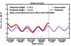
Like all plants, SAV needs sunlight to generate energy by photosynthesis, and SAV growth depends on light penetrating through the water to the leaves, particularly in the spring when new sprouts are coming up from the bottom. When excess nutrients foster the growth of phytoplankton, the light required by SAV is intercepted. Such excess nutrients also allow the growth of epiphytic algae on the leaves of SAV, further blocking light. Sediment suspended in the water has a light-blocking similar to phytoplankton. Thus, water clarity is essential for SAV growth, and any conditions reducing clarity will prevent SAV growth. As a general guide, if bright objects are visible 3 feet down from the surface, water clarity will be adequate for SAV. This corresponds to a 1 meter "Secchi depth," a simple but commonly used measure of water clarity, which is monitored in the Severn monthly by the Department of Natural Resources.
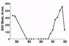
Because of the critical role SAV plays in providing habitat for crabs and fish, it is regarded as a particularly important measure of the health of estuarine and coastal waters. A group headed by Dr. Robert Orth at the Virginia Institute of Marine Sciences has made a serious effort to monitor SAV growth annually throughout the Chesapeake by aerial surveillance. Their data for the Severn is shown in the figure,which reveals the total demise of SAV in the 1980s followed by a dramatic recovery starting in 1994.
The progressive expansion of theSevern's SAV beds can be seen in the annual maps produced by VIMS (94,95,96,97,98,99,00) and resulted from natural spreading rather than SAV restoration efforts. These SAV beds are obvious to anyone using the Severn from Round Bay to the Route 50 bridge, and are a major SAV success story for the Chesapeake as a whole. The figure also shows a dramatic decline in SAV in 2000, illustrating the vulnerability of the Severn's recovery. The reason for this decline appears to be a dense growth of dinoflagellates in this region of the Chesapeake in late April and May. This bloom made the Severn look like dark tea just at the time SAV was beginning to grow, blocking light from reaching the young leaves. All species of SAV were affected, and for much of the summer very little SAV could be found. Neighboring tributaries on both sides of the Bay experienced similar SAV declines, correlating with the dinoflagellates bloom. Later in the fall of 2000 redhead grass and some widgeon grass grew back in the Severn (and is reflected in the acreage shown in the figure). In 2001 widgeon grass acreage still had not recovered to anything close to 1999 levels, although aerial surveys were not completed because of flight restrictions.