The Severn watershed covers an 81 square mile area, which is tiny compared to the 67,000 square mile area of the Chesapeake as a whole or the 27,000 of the Susquehanna. It is nevertheless larger than the watersheds of its immediate Western Shore neighbors, the Magothy, South or West Rivers. The Severn watershed extends in a northwest direction more than 7 miles from tidewater, nearly to the BWI parkway, although it is entirely in the coastal plain.
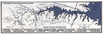
Some 20% of the watershed area is the tidal Severn River, while the other 80% is laced with many small freshwater streams that form a network flowing into the Severn.
The streams may issue as a spring where groundwater flows to the surface, or gather slowly amidst wet meadows. Never called brooks, the usual term in the Severn area is branch or, if larger, run. On the south side of the Severn the watershed is fairly broad, with some of the branches nearly a mile long. On the north side of the Severn proper, the watershed drops off sharply, and the small streams seldom receive notice. In developed areas many of the original streams have been replaced by stormwater systems of varying quality.
The quality of a watershed is the major determinant of the water quality of its' receiving waters, in our case the tidal Severn. Rainfall that arrives at streams or tidewater by flowing over the surface of land is termed runoff.
Basic information on Severn River watershed land use, etc. is available on the Bay Program site, which allows comparisons with other Chesapeake watersheds. Visualization of the watershed by aerial photography provides an opportunity to visualize the surfaces on which rain will fall. For developed areas with impervious surfaces, unfiltered nutrients and toxins will flow into streams and into the tidal Severn.In its natural state, most of the rainfall soaks into the ground where it is utilized by plants or descends into saturated layers of soil termed groundwater. Groundwater slowly flows to the Bay either directly or via springs and freshwater streams, and wells tapping this groundwater are the source of all drinking water in the area. Water flowing through soil is naturally filtered and purified by physical and microbiological processes, although groundwater can become contaminated with nitrogen nutrients or toxic chemicals. However, runoff water receives no filtering from soil, and when it enters streams and tidewater it carries with it all manner of sediment, nutrients and contaminants. Development converts surfaces from pervious to impervious, increasing runoff at the expense of groundwater recharge. Minimizing these impacts in order to preserve water quality is a major goal for urban planners and the Severn River Commission.